Earth Sandwich / City antipodes / Brussels
Antipode finder · Belgium
The antipode of
Brussels.
Draw a straight line from Brussels (50.85° N, 4.35° E) through the centre of the Earth and it comes out at 50.85° S, 175.65° W, in the South Pacific Ocean, 415 km from the nearest dry land, off the coast of New Zealand. The other slice of an Earth sandwich would sink.
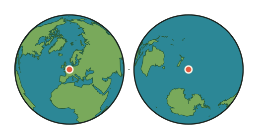
- Brussels
- 50.85° N, 4.35° E · about 40 m above sea level · 1,019,022 people
- Antipode
- 50.85° S, 175.65° W
- What is there
- The South Pacific Ocean; the sea floor there lies about 4,840 m below the surface
- Nearest dry land
- 415 km from the antipode, on the coast of New Zealand
- Nearest town
- Waitangi, New Zealand · 770 km from the antipode
- Nearest big city
- Auckland · 1,733 km from the antipode
- Sandwich verdict
- SOGGY the other slice lands in open water
- Nearest exact spot
- 419 km away, near Réville, France ⇄ 730 km from Waitangi, New Zealand
Can you make an Earth sandwich from Brussels?
No, not from Brussels itself. The other slice would land in the South Pacific Ocean, 415 km from the nearest dry land (New Zealand), where the sea floor lies about 4,840 m below the surface. Boats do not count (Sandwich Law § 1.3).
The nearest place from which an exact Earth sandwich is possible is 419 km from Brussels, 7 km from Réville, France. Its other slice would go down 730 km from Waitangi, New Zealand.
How this was worked out: the antipode flips the latitude and moves the longitude by 180°. Land or sea comes from the OpenStreetMap coastline the map uses; the sandwich verdict and elevations come from the verifier's 0.2° grid (Natural Earth land, ETOPO 2022 relief); water names from Natural Earth; towns and populations from GeoNames. The city's position is GeoNames' point for it; a big city's suburbs spread tens of kilometres around that point, and the figures move with them. Generated 2026-09-29.