Earth Sandwich / City antipodes / Port-au-Prince
Antipode finder · Haiti
The antipode of
Port-au-Prince.
Draw a straight line from Port-au-Prince (18.54° N, 72.34° W) through the centre of the Earth and it comes out at 18.54° S, 107.66° E, in the Indian Ocean, 757 km from the nearest dry land, off the coast of Australia. The other slice of an Earth sandwich would sink.
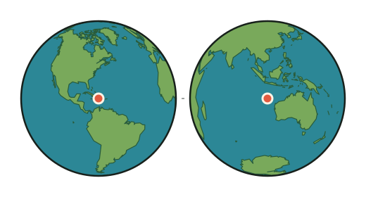
- Port-au-Prince
- 18.54° N, 72.34° W · about 600 m above sea level · 1,234,742 people
- Antipode
- 18.54° S, 107.66° E
- What is there
- The Indian Ocean; the sea floor there lies about 5,560 m below the surface
- Nearest dry land
- 757 km from the antipode, on the coast of Australia
- Nearest town
- Exmouth, Australia · 772 km from the antipode
- Nearest big city
- Bandung · 1,292 km from the antipode
- Sandwich verdict
- SOGGY the other slice lands in open water
- Nearest exact spot
- 1,200 km away, near El Regalo, Venezuela ⇄ near Pacitan, Indonesia
Can you make an Earth sandwich from Port-au-Prince?
No, not from Port-au-Prince itself. The other slice would land in the Indian Ocean, 757 km from the nearest dry land (Australia), where the sea floor lies about 5,560 m below the surface. Boats do not count (Sandwich Law § 1.3).
The nearest place from which an exact Earth sandwich is possible is 1,200 km from Port-au-Prince, 28 km from El Regalo, Venezuela. Its other slice would go down 13 km from Pacitan, Indonesia.
How this was worked out: the antipode flips the latitude and moves the longitude by 180°. Land or sea comes from the OpenStreetMap coastline the map uses; the sandwich verdict and elevations come from the verifier's 0.2° grid (Natural Earth land, ETOPO 2022 relief); water names from Natural Earth; towns and populations from GeoNames. The city's position is GeoNames' point for it; a big city's suburbs spread tens of kilometres around that point, and the figures move with them. Generated 2026-09-29.