Earth Sandwich / City antipodes / Sokoto
Antipode finder · Nigeria
The antipode of
Sokoto.
Draw a straight line from Sokoto (13.06° N, 5.24° E) through the centre of the Earth and it comes out at 13.06° S, 174.76° W, in the South Pacific Ocean, 150 km from the nearest dry land, off the coast of Wallis and Futuna. A sloppy Earth sandwich is possible.
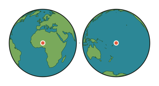
- Sokoto
- 13.06° N, 5.24° E · about 280 m above sea level · 1,040,000 people
- Antipode
- 13.06° S, 174.76° W
- What is there
- The South Pacific Ocean; the sea floor there lies about 1,960 m below the surface
- Nearest dry land
- 150 km from the antipode, on the coast of Wallis and Futuna
- Nearest town
- Mata-Utu, Wallis and Futuna · 155 km from the antipode
- Nearest big city
- Auckland · 2,843 km from the antipode
- Sandwich verdict
- SLOPPY dry land within 200 km of the antipode
Can you make an Earth sandwich from Sokoto?
Nearly: a sloppy-grade Earth sandwich. The antipode of Sokoto lies in the South Pacific Ocean, 150 km from the nearest dry land in Wallis and Futuna. Sandwich Law allows a slice within 200 km of the true antipode, and the verifying grid rates Sokoto sloppy, so bread in Sokoto and bread near Mata-Utu, Wallis and Futuna still count as one sandwich. The elevation bonus depends on the spot chosen for the dry slice.
Sokoto is on the The South Pacific ↔ the Sahara & Sahel corridor. Its guide lists where every city on both sides lands and how to make an Earth sandwich there.
How this was worked out: the antipode flips the latitude and moves the longitude by 180°. Land or sea comes from the OpenStreetMap coastline the map uses; the sandwich verdict and elevations come from the verifier's 0.2° grid (Natural Earth land, ETOPO 2022 relief); water names from Natural Earth; towns and populations from GeoNames. The city's position is GeoNames' point for it; a big city's suburbs spread tens of kilometres around that point, and the figures move with them. Generated 2026-09-29.