Earth Sandwich / Corridors / The South Pacific ↔ the Sahara & Sahel
Corridor guide · The South Pacific ↔ the Sahara & Sahel
Fiji, meet
Timbuktu.
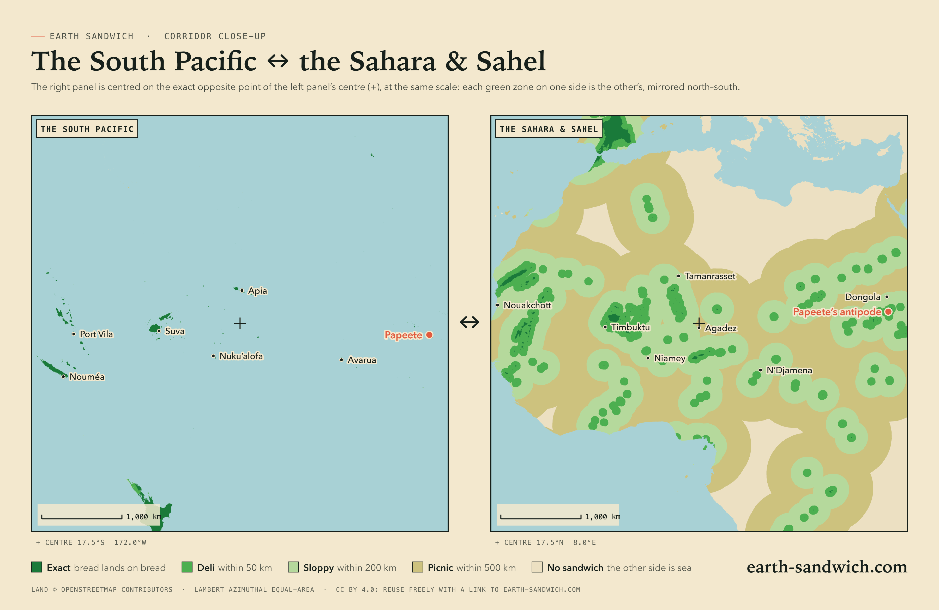
The island nations of the South Pacific are small, and almost every one of them lies exactly opposite dry land, in the Sahara and the Sahel. Fiji faces Mali, around Timbuktu; Samoa faces Niger; Tonga the far south of Algeria; Tahiti the desert of northern Sudan; Vanuatu and New Caledonia Mauritania and the Western Sahara. Everyone in Fiji, Samoa, Tonga and Vanuatu lives on land with land opposite. Getting bread to the other end is another matter.
How it lines up Every city Town twins The highest Timing Finding a partner
How the two sides line up
Fiji lands on the Niger bend in Mali. Viti Levu faces the country around Timbuktu and Gourma-Rharous, Vanua Levu the river towns of Gao and Bourem. Samoa lands in southern Niger, Apia 28 km from Tessaoua, and American Samoa and Wallis nearby, in the Zinder and Dosso regions. Tonga falls on the far south of Algeria, between Tamanrasset and the Niger border at In Guezzam; Niue on the edge of the Aïr and the Ténéré, in Niger. Tahiti lands in the desert of northern Sudan, Papeete 79 km from Ad Dabbah on the Nile. The Cook Islands face the desert of northern Chad.
To the west, Vanuatu lands in Mauritania, Luganville 2 km from Maghama on the Senegal River, and New Caledonia in the desert of the Western Sahara and Mauritania. To the east the pairs get stranger. The Marquesas land on the Rift Valley of Ethiopia, Taiohae 2 km from the antipode of Metahāra. Kiritimati faces the forest of central Congo, Pitcairn the Eastern Province of Saudi Arabia, and Easter Island the Thar Desert near Jaisalmer, in India. Tuvalu’s Funafuti lands in northern Ghana.
The misses: the Gilbert Islands of Kiribati, Tarawa included, face the Atlantic off West Africa (637 km from land). And Africa’s big cities mostly face open Pacific between the islands: Timbuktu itself is a deli sandwich, 39 km short of Fiji; Khartoum is 26 km short of the Tuamotus; Addis Ababa 80 km short of the Marquesas.
Every town, and where its other slice lands
The capitals and main towns of Fiji, Samoa, American Samoa, Tonga, Vanuatu, New Caledonia, French Polynesia, the Cook Islands, Kiribati, Niue, Wallis and Futuna, Tuvalu, Pitcairn and Easter Island. On the other side, the capitals, regional capitals and cities above 100,000 across the Sahara, the Sahel and the Horn of Africa, with Arabia and India’s Thar, each listed if its other slice lands within 50 km of one of these islands, or it is a capital or a city of a million. Exact means land opposite land at the town’s own point; where the other slice would get wet, the table gives the nearest spot from which an exact sandwich is possible.
| Place | Verdict | Where the other slice lands |
|---|---|---|
| Mali | ||
| Bamako4,227,569 | SOGGY | South Pacific Ocean, 214 km from dry landNearest exact spot: 499 km away, 69 km from Goudiry (Tambacounda, Senegal) |
| Gao133,110 | DELI | South Pacific Ocean, 7 km from dry landNearest exact spot: 7 km away, near Gao |
| TimbuktuTombouctou · 84,208 | DELI | South Pacific Ocean, 39 km from dry landNearest exact spot: 53 km away, 53 km from Timbuktu (Tombouctou) |
| Kidal40,030 | DELI | South Pacific Ocean, 12 km from dry landNearest exact spot: 54 km away, 54 km from Kidal |
| Niger | ||
| Niamey1,323,691 | SLOPPY | South Pacific Ocean, 87 km from dry landNearest exact spot: 87 km away, near Ouallam (Tillabéri Region) |
| MaradiMaradi Region · 361,702 | DELI | South Pacific Ocean, 10 km from dry landNearest exact spot: 11 km away, near Maradi (Maradi Region) |
| ZinderZinder Region · 318,874 | DELI | South Pacific Ocean, 48 km from dry landNearest exact spot: 50 km away, 36 km from Takiéta (Zinder Region) |
| TillabériTillabéri Region · 30,822 | DELI | South Pacific Ocean, 40 km from dry landNearest exact spot: 40 km away, near Ouallam (Tillabéri Region) |
| Nigeria | ||
| Lagos15,388,000 | SOGGY | South Pacific Ocean, 302 km from dry landNearest exact spot: 752 km away, near Tibiri (Dosso Region, Niger) |
| KanoKano State · 4,910,000 | SLOPPY | South Pacific Ocean, 113 km from dry landNearest exact spot: 185 km away, near Aguié (Maradi Region, Niger) |
| IbadanOyo State · 3,649,000 | SOGGY | South Pacific Ocean, 346 km from dry landNearest exact spot: 647 km away, near Tibiri (Dosso Region, Niger) |
| Port HarcourtRivers State · 2,120,000 | SLOPPY | South Pacific Ocean, 89 km from dry landNearest exact spot: 969 km away, near Maradi (Maradi Region, Niger) |
| Benin CityEdo State · 1,782,000 | SLOPPY | South Pacific Ocean, 183 km from dry landNearest exact spot: 788 km away, near Tibiri (Dosso Region, Niger) |
| OnitshaAnambra · 1,553,000 | SOGGY | South Pacific Ocean, 211 km from dry landNearest exact spot: 818 km away, near Maradi (Maradi Region, Niger) |
| AbaAbia State · 1,160,000 | SLOPPY | South Pacific Ocean, 79 km from dry landNearest exact spot: 932 km away, 32 km from Maradi (Maradi Region, Niger) |
| MaiduguriBorno State · 1,110,000 | SLOPPY | South Pacific Ocean, 146 km from dry landNearest exact spot: 384 km away, 43 km from Gouré (Zinder Region, Niger) |
| Sokoto1,040,000 | SLOPPY | South Pacific Ocean, 150 km from dry landNearest exact spot: 150 km away, near Tibiri (Dosso Region, Niger) |
| Algeria | ||
| In Guezzam7,045 | DELI | South Pacific Ocean, 11 km from dry landNearest exact spot: 11 km away, near In Guezzam |
| Mauritania | ||
| Nouakchott1,184,530 | SLOPPY | Coral Sea, 105 km from dry landNearest exact spot: 175 km away, 32 km from Nouâmghâr (Dakhlet Nouadhibou) |
| KiffaAssaba · 62,051 | DELI | South Pacific Ocean, 22 km from dry landNearest exact spot: 31 km away, 31 km from Kiffa (Assaba) |
| ZouératTiris Zemmour · 55,183 | DELI | South Pacific Ocean, 3 km from dry landNearest exact spot: 3 km away, near Zouérat (Tiris Zemmour) |
| SélibabyGuidimaka · 32,653 | DELI | Coral Sea, 17 km from dry landNearest exact spot: 17 km away, near Hassi Chegar (Guidimaka) |
| AtarAdrar · 31,133 | DELI | Coral Sea, 25 km from dry landNearest exact spot: 25 km away, near Atar (Adrar) |
| TidjikjaTagant · 13,479 | DELI | Coral Sea, 47 km from dry landNearest exact spot: 47 km away, 47 km from Tidjikja (Tagant) |
| Senegal | ||
| PikineDakar · 1,170,791 | SOGGY | Coral Sea, 366 km from dry landNearest exact spot: 423 km away, 70 km from Sémé (Matam) |
| ToubaDiourbel Region · 1,120,824 | SOGGY | Coral Sea, 260 km from dry landNearest exact spot: 260 km away, 67 km from Sémé (Matam) |
| Matam27,695 | DELI | Coral Sea, 3 km from dry landNearest exact spot: 7 km away, near Matam |
| Sudan | ||
| Khartoum1,974,647 | DELI | South Pacific Ocean, 26 km from dry landNearest exact spot: 87 km away, 78 km from Omdurman (Khartoum) |
| OmdurmanKhartoum · 1,849,659 | DELI | South Pacific Ocean, 37 km from dry landNearest exact spot: 78 km away, 78 km from Omdurman (Khartoum) |
| Al QadarifAl Qaḑārif · 363,945 | DELI | South Pacific Ocean, 48 km from dry landNearest exact spot: 249 km away, 124 km from Shendi (River Nile) |
| Wad MedaniAl Jazirah · 332,714 | DELI | South Pacific Ocean, 14 km from dry landNearest exact spot: 192 km away, 68 km from Shendi (River Nile) |
| Al-FulahWest Kordofan | DELI | South Pacific Ocean, 34 km from dry landNearest exact spot: 544 km away, 308 km from Ad Dabbah (Northern State) |
| Chad | ||
| N'DjamenaN’Djaména · 1,359,526 | SLOPPY | South Pacific Ocean, 78 km from dry landNearest exact spot: 537 km away, 43 km from Gouré (Zinder Region, Niger) |
| Ethiopia | ||
| Addis Ababa3,860,000 | SLOPPY | South Pacific Ocean, 80 km from dry landNearest exact spot: 116 km away, near Metahāra (Oromiya) |
| NazrētOromiya · 456,900 | DELI | South Pacific Ocean, 19 km from dry landNearest exact spot: 65 km away, near Metahāra (Oromiya) |
| BishoftuOromiya · 207,400 | DELI | South Pacific Ocean, 45 km from dry landNearest exact spot: 90 km away, near Metahāra (Oromiya) |
| Debre BirhanAmhara · 146,900 | DELI | South Pacific Ocean, 49 km from dry landNearest exact spot: 49 km away, 49 km from Debre Birhan (Amhara) |
| ĀselaOromiya · 139,500 | DELI | South Pacific Ocean, 17 km from dry landNearest exact spot: 120 km away, near Metahāra (Oromiya) |
| Inda SilasēTigray · 100,100 | DELI | South Pacific Ocean, 30 km from dry landNearest exact spot: 363 km away, 144 km from Tokār (Red Sea, Sudan) |
| Democratic Republic of the Congo | ||
| Mbuji-MayiEast Kasai · 2,101,332 | SOGGY | North Pacific Ocean, 404 km from dry landNearest exact spot: 472 km away, 199 km from Lodja (Sankuru) |
| KanangaKasai-Central · 1,247,168 | SOGGY | North Pacific Ocean, 292 km from dry landNearest exact spot: 434 km away, 202 km from Lodja (Sankuru) |
| KisanganiTshopo · 1,181,788 | SOGGY | South Pacific Ocean, 360 km from dry landNearest exact spot: 363 km away, 221 km from Lodja (Sankuru) |
| IleboKasai · 117,245 | DELI | North Pacific Ocean, 44 km from dry landNearest exact spot: 342 km away, 202 km from Lodja (Sankuru) |
| Saudi Arabia | ||
| JeddahMecca Region · 4,697,000 | DELI | South Pacific Ocean, 24 km from dry landNearest exact spot: 24 km away, near Jeddah (Mecca Region) |
| RiyadhRiyadh Region · 4,205,961 | SLOPPY | South Pacific Ocean, 190 km from dry landNearest exact spot: 820 km away, 31 km from Jeddah (Mecca Region) |
| MakkahMecca Region · 1,578,722 | SLOPPY | South Pacific Ocean, 51 km from dry landNearest exact spot: 51 km away, near Jeddah (Mecca Region) |
| MadinahMedina Region · 1,300,000 | SOGGY | South Pacific Ocean, 295 km from dry landNearest exact spot: 307 km away, 32 km from Jeddah (Mecca Region) |
| DammamEastern Province · 1,252,523 | SLOPPY | South Pacific Ocean, 152 km from dry landNearest exact spot: 1,208 km away, 31 km from Jeddah (Mecca Region) |
| Khamis Mushait'Asir Region · 387,553 | DELI | South Pacific Ocean, 22 km from dry landNearest exact spot: 458 km away, 143 km from Tokār (Red Sea, Sudan) |
| Al HufūfEastern Province · 293,179 | DELI | South Pacific Ocean, 44 km from dry landNearest exact spot: 1,116 km away, 31 km from Jeddah (Mecca Region) |
| Abha'Asir Region · 210,886 | DELI | South Pacific Ocean, 46 km from dry landNearest exact spot: 432 km away, 143 km from Tokār (Red Sea, Sudan) |
| Egypt | ||
| Cairo9,606,916 | SOGGY | South Pacific Ocean, 505 km from dry landNearest exact spot: 1,231 km away, near Jeddah (Mecca Region, Saudi Arabia) |
| Alexandria5,263,542 | SOGGY | South Pacific Ocean, 681 km from dry landNearest exact spot: 1,410 km away, near Jeddah (Mecca Region, Saudi Arabia) |
| Giza4,367,343 | SOGGY | South Pacific Ocean, 506 km from dry landNearest exact spot: 1,229 km away, near Jeddah (Mecca Region, Saudi Arabia) |
| Burkina Faso | ||
| OuagadougouCentre · 2,415,266 | SLOPPY | South Pacific Ocean, 145 km from dry landNearest exact spot: 419 km away, near Ouallam (Tillabéri Region, Niger) |
| DédougouBoucle du Mouhoun · 63,617 | DELI | South Pacific Ocean, 43 km from dry landNearest exact spot: 479 km away, 59 km from Gourma Rharous (Tombouctou, Mali) |
| South Sudan | ||
| JubaCentral Equatoria · 450,000 | SOGGY | South Pacific Ocean, 595 km from dry landNearest exact spot: 724 km away, 115 km from Zemio (Haut-Mbomou, Central African Republic) |
| Eritrea | ||
| AsmaraMaekel · 563,930 | SLOPPY | South Pacific Ocean, 57 km from dry landNearest exact spot: 230 km away, 144 km from Tokār (Red Sea, Sudan) |
| MassawaNorthern Red Sea · 23,100 | DELI | South Pacific Ocean, 40 km from dry landNearest exact spot: 221 km away, 144 km from Tokār (Red Sea, Sudan) |
| Cameroon | ||
| MarouaFar North · 314,122 | DELI | South Pacific Ocean, 33 km from dry landNearest exact spot: 572 km away, 43 km from Gouré (Zinder Region, Niger) |
Town twins
No two towns here are within a kilometre of each other’s antipode, though some come close: Luganville and Maghama, and Taiohae and Metahāra, are about two kilometres apart. Every island town in the first table is exact.
The highest sandwiches
A sandwich’s elevation bonus is the height of one end plus the height of the other (Sandwich Law § 1.4). The Board scores it the way the map shows it: from the average height of the ground over cells about 20 km across, so every spot in a cell scores the same and you only need to be in the right cell, not on the summit. These are the corridor’s best cells, one per area, each with dry land at both ends.
- +1,280 m1 km from Taiohae (Marquesas Islands, French Polynesia)cell average 200 m2 km from Metahāra (Oromiya, Ethiopia)cell average 1,080 m
- +1,120 m15 km from Gataivai (Palauli, Samoa)cell average 680 m34 km from Mayahi (Maradi Region, Niger)cell average 440 m
- +800 m23 km from Vatukoula (Western, Fiji)cell average 520 m93 km from Gourma Rharous (Tombouctou, Mali)cell average 280 m
- +720 m4 km from Lauli’i (Samoa)cell average 280 m35 km from Takiéta (Zinder Region, Niger)cell average 440 m
- +720 m26 km from Bouloupari (South Province, New Caledonia)cell average 520 m94 km from Choum (Adrar, Mauritania)cell average 200 m
The best cell pairs the ridge above Taiohae on Nuku Hiva with the Ethiopian Rift near Metahāra, at an average of 1,080 m: the Marquesas are the one island group here whose twin is in the highlands.
Timing it
The window. Both slices must go down within five minutes of the same UTC instant (Sandwich Law § 2.1). The sandwich lobby holds you to it: when the first slice lands, the other side has five minutes.
The clocks. The date line runs through this corridor. Fiji is 12 hours ahead of Mali, Samoa and Tonga 12 hours ahead of Niger and Algeria, and Kiritimati 12 hours ahead of central Congo, so at noon UTC it is already tomorrow on those islands. Tahiti is 12 hours behind Sudan, and the Marquesas 12½ hours behind Ethiopia: the same noon is still today there. Agree the minute in UTC and let the calendars sort themselves out.
The light. Two exactly opposite points are never in daylight together: sunrise at one end is sunset at the other. The atmosphere bends a little sunlight over the horizon, so twice a day, on a clear flat horizon, the sun is up at both ends at once for about seven to eight minutes. Put the bread down then and both photographs get golden light, one at dusk and one at dawn.
The seasons. Opposite. The Sahel’s rains come in the northern summer, which is the islands’ dry season; the Saharan summer is fiercely hot.
Finding the other slice
The geometry is the easy part; the hard part is a person at the other end, and the site does not match strangers. Many of the African twins lie in parts of Mali, Niger, Chad, Burkina Faso and Sudan that are covered by travel warnings: check your government’s advice before you plan anything, and do not ask anyone to put themselves at risk for bread. Mauritania, Ethiopia, Ghana and the Thar Desert are easier places to start.
Then open an attempt in the sandwich lobby. It gives you a code and a link to send through whatever channel you already share, shows both slices when they arrive, and runs the five-minute window. The desert ends are remote: go with people who know the ground, and carry water. The exact grade allows a kilometre of slack, which is usually enough to find somewhere you are allowed to stand.
City antipodes on this corridor
Lagos · Cairo · Alexandria · Kano · Jeddah · Giza · Bamako · Riyadh · Addis Ababa · Ibadan · Ouagadougou · Port Harcourt · Mbuji-Mayi · Khartoum · Omdurman · Benin City · Makkah · Onitsha · N'Djamena · Niamey · Madinah · Dammam · Kananga · Nouakchott · Kisangani · Pikine · Aba · Touba · Maiduguri · Sokoto
How this was worked out: towns, populations and their centre points from GeoNames (a place within 20 km of one three times its size is left out as its suburb); land or sea from the OpenStreetMap coastline the map uses; verdicts at each place’s own point, nearest exact spots and elevation bonuses from the same coastline and the verifier’s 0.2° grid (Natural Earth land, ETOPO 2022 relief); sea names and borders from Natural Earth; the share of people with land opposite from GHS-POP 2020 (European Commission, Joint Research Centre, CC BY 4.0), at about 1 km resolution. Clock and daylight figures are for exactly opposite points on a sphere with standard refraction. Generated 2026-09-29.