Earth Sandwich / Corridors / Indonesia & Malaysia ↔ Colombia, Ecuador & the Amazon
Corridor guide · Indonesia, Malaysia & Singapore ↔ Colombia, Ecuador, Venezuela & the Amazon
Java, meet
the Andes.
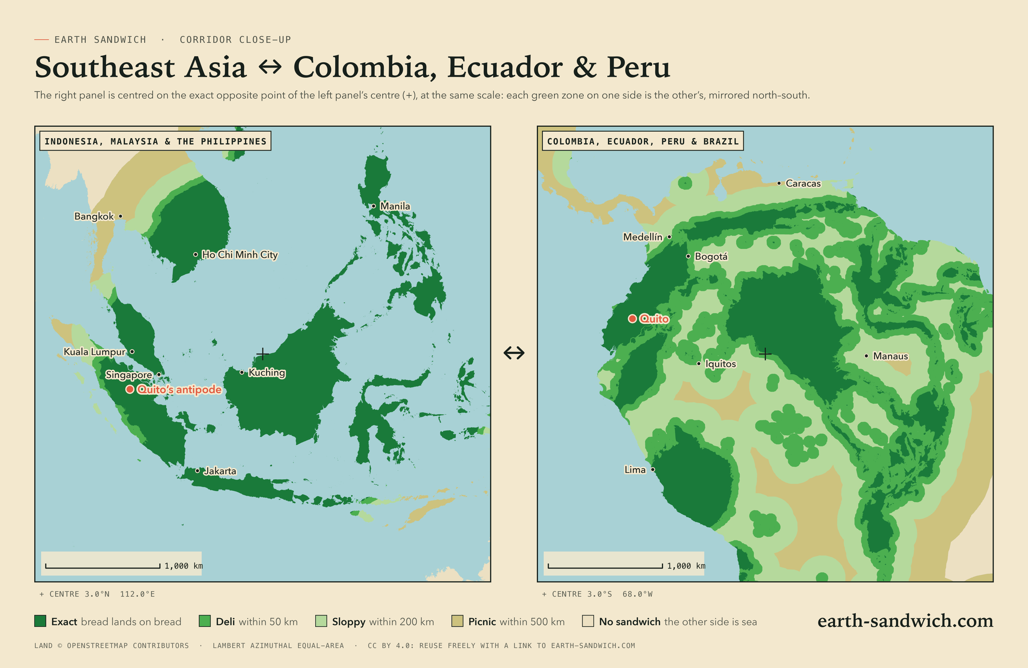
Almost all of western Indonesia and every part of Malaysia lie exactly opposite northern South America. Java sits on the Colombian Andes, Sumatra on Ecuador, Borneo on the Amazon. 231.3 million Indonesians live on land with land opposite, more people than on any corridor except China’s, and this is where real cities come closest to being each other’s antipode: Padang and Esmeraldas, Batu and San Fernando de Apure, Palembang and Neiva.
How it lines up Every city Twins The highest Timing Finding a partner
How the two sides line up
Java lands on the Colombian Andes. Jakarta comes down 8 km from Charalá, in Santander; Bogor, Depok and the rest of greater Jakarta across the same mountains of Santander; Bandung near Cubará on the Venezuelan border. Sumatra covers Ecuador and southern Colombia: Pekanbaru is 1 km from Machachi, just south of Quito, and Quito faces Pekanbaru in turn; Guayaquil lands in North Sumatra; Padang lands 1 km from Esmeraldas on the Ecuadorian coast.
Malaysia sits on the Amazon of Ecuador and Peru: Kuala Lumpur 23 km from General Leonidas Plaza Gutiérrez, in Morona-Santiago, and Singapore in the Ecuadorian Amazon near Tiputini. Borneo’s outline comes down on the Amazon upside down, Kuching and Pontianak in the Colombian Amazon near Tarapacá and Carurú, Bandar Seri Begawan in Brazil’s Amazonas state near Tefé; and Sulawesi lands in Roraima: Makassar near Uiramutã on the Guyana border, while Boa Vista faces the Sulawesi highlands near Mamasa. Surabaya and eastern Java face the llanos of Apure, in Venezuela.
The east misses. Papua and Timor face the Atlantic off north-east Brazil (Jayapura’s antipode is 603 km from land), and the northern tip of Sumatra faces the Pacific off Ecuador and Peru. Bogotá itself lands in the Java Sea, 2 km off the north coast of Java: a deli sandwich from the city centre, and an exact one 2 km away. Caracas and most of northern Venezuela face the Indian Ocean south of Java.
Every city, and where its other slice lands
Every Indonesian city above half a million people and every provincial capital, every Malaysian city above 300,000 and every state capital, Singapore, Brunei and Dili. On the other side, the cities of Colombia, Ecuador, Venezuela and Peru above 150,000 to 250,000 people and every regional capital, the state capitals and larger cities of the Brazilian north, and the capitals of the Guianas, each listed if its other slice lands in or off Indonesia, Malaysia, Singapore, Brunei or Timor. Exact means land opposite land at the city’s own point; where the other slice would get wet, the table gives the nearest spot from which an exact sandwich is possible.
| Place | Verdict | Where the other slice lands |
|---|---|---|
| Colombia | ||
| BogotáBogota D.C. · 7,674,366 | DELI | Java Sea, 2 km from dry landNearest exact spot: 2 km away, near Bogotá (Bogota D.C.) |
| CaliValle del Cauca Department · 2,392,877 | EXACT | Dry land 33 km from Bunga Mas (South Sumatra) |
| MedellínAntioquia · 1,999,979 | DELI | Indian Ocean, 38 km from dry landNearest exact spot: 38 km away, near La Unión (Antioquia) |
| CúcutaNorte de Santander Department · 777,106 | DELI | Indian Ocean, 34 km from dry landNearest exact spot: 34 km away, near Santa Ana (Táchira, Venezuela) |
| BucaramangaSantander Department · 581,130 | EXACT | Dry land 10 km from Puncaktugu (West Java) |
| IbaguéTolima Department · 529,635 | EXACT | Dry land 25 km from Negararatu (Lampung) |
| PereiraRisaralda Department · 467,269 | EXACT | Dry land 19 km from Kasui (Lampung) |
| ManizalesCaldas Department · 434,403 | EXACT | Dry land 25 km from Bukitkemuning (Lampung) |
| BuenaventuraValle del Cauca Department · 432,385 | EXACT | Dry land 9 km from Tebing Tinggi (South Sumatra) |
| PastoNariño · 392,930 | EXACT | Dry land 41 km from Pelabuhan Dagang (Jambi) |
| NeivaHuila Department · 357,392 | EXACT | Dry land 3 km from Palembang (South Sumatra) |
| VillavicencioMeta Department · 321,717 | SLOPPY | Java Sea, 56 km from dry landNearest exact spot: 57 km away, near Gutiérrez (Cundinamarca) |
| PopayánCauca Department · 318,059 | EXACT | Dry land 36 km from Bingintelok (South Sumatra) |
| PalmiraValle del Cauca Department · 312,519 | EXACT | Dry land 15 km from Muara Enim (South Sumatra) |
| ArmeniaQuindío Department · 304,314 | EXACT | Dry land 18 km from Simpang (South Sumatra) |
| FloridablancaSantander Department · 267,591 | EXACT | Dry land 4 km from Nyalindung (West Java) |
| TuluáValle del Cauca Department · 221,684 | EXACT | Dry land 9 km from Pengandonan (South Sumatra) |
| DosquebradasRisaralda Department · 206,693 | EXACT | Dry land 19 km from Kasui (Lampung) |
| TunjaBoyacá · 172,548 | DELI | Java Sea, 6 km from dry landNearest exact spot: 49 km away, near Puente Nacional (Santander Department) |
| YopalCasanare Department · 168,433 | SLOPPY | Java Sea, 77 km from dry landNearest exact spot: 92 km away, near Cerinza (Boyacá) |
| FlorenciaCaquetá · 168,346 | EXACT | Dry land 51 km from Simpang (Jambi) |
| QuibdóChocó · 129,237 | SLOPPY | Indian Ocean, 81 km from dry landNearest exact spot: 88 km away, near La Merced (Risaralda Department) |
| AraucaArauca Department · 85,585 | EXACT | Dry land 9 km from Randudongkal (Central Java) |
| MocoaPutumayo Department · 56,398 | EXACT | Dry land 29 km from Pelabuhan Dagang (Jambi) |
| San José del GuaviareGuaviare Department · 52,815 | DELI | Java Sea, 26 km from dry landNearest exact spot: 26 km away, near San José del Guaviare (Guaviare Department) |
| LeticiaAmazonas Department · 48,144 | SLOPPY | South China Sea, 183 km from dry landNearest exact spot: 185 km away, 71 km from Remanso (Loreto, Peru) |
| MitúVaupés · 29,850 | DELI | South China Sea, 10 km from dry landNearest exact spot: 17 km away, near Mitú (Vaupés) |
| Puerto CarreñoVichada Department · 20,936 | DELI | Java Sea, 37 km from dry landNearest exact spot: 44 km away, near Puerto Ayacucho (Amazonas, Venezuela) |
| IníridaGuainía Department · 7,298 | DELI | Java Sea, 41 km from dry landNearest exact spot: 41 km away, 41 km from Inírida (Guainía Department) |
| Ecuador | ||
| QuitoPichincha · 2,781,641 | EXACT | Dry land 32 km from Pekanbaru (Riau) |
| GuayaquilGuayas · 2,723,665 | EXACT | Dry land 17 km from Rantau Prapat (North Sumatra) |
| CuencaAzuay · 636,996 | DELI | Strait of Malacca, 22 km from dry landNearest exact spot: 23 km away, near Chordeleg (Azuay) |
| Santo Domingo de los ColoradosSanto Domingo de los Tsáchilas · 458,580 | EXACT | Dry land 24 km from Bangkinang (Riau) |
| AmbatoTungurahua Province · 387,309 | EXACT | Dry land 21 km from Duri (Riau) |
| PortoviejoManabí · 321,800 | EXACT | Dry land 8 km from Siabu (North Sumatra) |
| MachalaEl Oro · 289,141 | DELI | Strait of Malacca, 30 km from dry landNearest exact spot: 32 km away, 31 km from Puerto Bolívar (El Oro) |
| Loja274,112 | EXACT | Dry land 2 km from Bagan Datuk (Perak, Malaysia) |
| MantaManabí · 264,281 | EXACT | Dry land 26 km from Siabu (North Sumatra) |
| RiobambaChimborazo Province · 264,048 | EXACT | Dry land 11 km from Dumai (Riau) |
| IbarraImbabura · 221,149 | EXACT | Dry land 18 km from Cerenti (Riau) |
| Esmeraldas218,727 | DELI | Indian Ocean, under 1 km from dry landNearest exact spot: under 1 km away, near Esmeraldas |
| QuevedoLos Ríos · 213,842 | EXACT | Dry land 7 km from Kota Tengah (Riau) |
| LatacungaCotopaxi · 205,624 | EXACT | Dry land 17 km from Balai Pungut (Riau) |
| DauleGuayas · 173,684 | EXACT | Dry land 8 km from Kota Pinang (North Sumatra) |
| TulcánCarchi · 86,498 | EXACT | Dry land 28 km from Pangkalan Kasai (Riau) |
| BabahoyoLos Ríos · 76,279 | EXACT | Dry land 44 km from Kota Pinang (North Sumatra) |
| Puerto Francisco de OrellanaOrellana Province · 48,144 | EXACT | Dry land 31 km from Teluk Dalam (Riau) |
| Santa Elena42,214 | EXACT | Dry land 15 km from Balige (North Sumatra) |
| AzoguesCanar · 34,877 | DELI | Strait of Malacca, 20 km from dry landNearest exact spot: 20 km away, near Mariano Moreno (Azuay) |
| PuyoPastaza Province · 24,881 | DELI | Strait of Malacca, 2 km from dry landNearest exact spot: 2 km away, near Puyo (Pastaza Province) |
| Nueva LojaSucumbíos · 24,211 | EXACT | Dry land 27 km from Tembilahan (Riau) |
| MacasMorona-Santiago Province · 23,687 | DELI | Strait of Malacca, 11 km from dry landNearest exact spot: 11 km away, near Sucúa (Morona-Santiago Province) |
| GuarandaBolívar · 22,199 | EXACT | Dry land 4 km from Sedinginan (Riau) |
| TenaNapo · 17,172 | EXACT | Dry land 27 km from Siak Sri Indrapura (Riau) |
| ZamoraZamora Chinchipe · 15,276 | EXACT | Dry land 6 km from Teluk Intan (Perak, Malaysia) |
| Puerto Baquerizo MorenoGalápagos · 7,290 | SOGGY | Indian Ocean, 601 km from dry landNearest exact spot: 968 km away, near Salinas (Santa Elena) |
| Venezuela | ||
| CaracasDistrito Federal · 3,000,000 | SOGGY | Indian Ocean, 221 km from dry landNearest exact spot: 221 km away, 74 km from Las Mercedes (Guárico) |
| ValenciaCarabobo · 1,619,470 | SLOPPY | Indian Ocean, 198 km from dry landNearest exact spot: 206 km away, near Guadarrama (Barinas) |
| BarquisimetoLara · 1,240,714 | SOGGY | Indian Ocean, 205 km from dry landNearest exact spot: 205 km away, near El Regalo (Barinas) |
| Ciudad GuayanaBolívar · 978,202 | DELI | Flores Sea, 9 km from dry landNearest exact spot: 9 km away, near Ciudad Guayana (Bolívar) |
| BarcelonaAnzoátegui · 815,141 | SLOPPY | Indian Ocean, 144 km from dry landNearest exact spot: 144 km away, near Pariaguán (Anzoátegui) |
| MaturínMonagas · 647,459 | SLOPPY | Indian Ocean, 75 km from dry landNearest exact spot: 75 km away, 40 km from Temblador (Monagas) |
| MaracayAragua · 464,700 | SOGGY | Indian Ocean, 201 km from dry landNearest exact spot: 206 km away, 33 km from La Unión (Barinas) |
| Ciudad BolívarBolívar · 412,619 | DELI | Bali Sea, 12 km from dry landNearest exact spot: 12 km away, near Soledad (Anzoátegui) |
| CumanáSucre · 405,626 | SLOPPY | Indian Ocean, 175 km from dry landNearest exact spot: 175 km away, near San José de Guanipa (Anzoátegui) |
| Barinas397,279 | SLOPPY | Indian Ocean, 85 km from dry landNearest exact spot: 85 km away, near San Rafael de Canaguá (Barinas) |
| Puerto La CruzAnzoátegui · 370,000 | SLOPPY | Indian Ocean, 153 km from dry landNearest exact spot: 153 km away, near Pariaguán (Anzoátegui) |
| CabimasZulia · 351,736 | SOGGY | Indian Ocean, 287 km from dry landNearest exact spot: 289 km away, near Santa María de Caparo (Mérida) |
| TurmeroAragua · 344,700 | SLOPPY | Indian Ocean, 197 km from dry landNearest exact spot: 210 km away, 74 km from Las Mercedes (Guárico) |
| Mérida300,000 | SLOPPY | Indian Ocean, 91 km from dry landNearest exact spot: 91 km away, near Pedraza La Vieja (Barinas) |
| San CristóbalTáchira · 289,852 | DELI | Indian Ocean, 9 km from dry landNearest exact spot: 9 km away, near San Josecito (Táchira) |
| Alto BarinasBarinas · 284,289 | SLOPPY | Indian Ocean, 82 km from dry landNearest exact spot: 82 km away, near San Rafael de Canaguá (Barinas) |
| Santa Teresa del TuyMiranda · 278,890 | SLOPPY | Indian Ocean, 192 km from dry landNearest exact spot: 192 km away, 74 km from Las Mercedes (Guárico) |
| Los TequesMiranda · 252,242 | SOGGY | Indian Ocean, 208 km from dry landNearest exact spot: 208 km away, 74 km from Las Mercedes (Guárico) |
| CoroFalcón · 246,657 | SOGGY | Indian Ocean, 358 km from dry landNearest exact spot: 358 km away, near El Regalo (Barinas) |
| San Fernando de ApureApure · 229,197 | EXACT | Dry land 2 km from Batu (East Java) |
| San FelipeYaracuy · 206,270 | SOGGY | Indian Ocean, 221 km from dry landNearest exact spot: 230 km away, 44 km from Arismendi (Barinas) |
| San Juan de los MorrosGuárico · 160,868 | SLOPPY | Indian Ocean, 161 km from dry landNearest exact spot: 172 km away, 74 km from Las Mercedes (Guárico) |
| Puerto AyacuchoAmazonas · 125,840 | DELI | Java Sea, 24 km from dry landNearest exact spot: 25 km away, near Puerto Ayacucho (Amazonas) |
| San CarlosCojedes · 120,375 | SLOPPY | Indian Ocean, 144 km from dry landNearest exact spot: 144 km away, near Arismendi (Barinas) |
| GuanarePortuguesa · 112,286 | SLOPPY | Indian Ocean, 105 km from dry landNearest exact spot: 105 km away, near Las Casitas del Vegon de Nutrias (Barinas) |
| TucupitaDelta Amacuro · 99,778 | DELI | Indian Ocean, 15 km from dry landNearest exact spot: 15 km away, near Tucupita (Delta Amacuro) |
| Trujillo71,362 | SLOPPY | Indian Ocean, 169 km from dry landNearest exact spot: 171 km away, near San Rafael de Canaguá (Barinas) |
| La AsunciónNueva Esparta · 35,084 | SOGGY | Indian Ocean, 233 km from dry landNearest exact spot: 233 km away, 61 km from Temblador (Monagas) |
| Peru | ||
| Piura630,000 | SLOPPY | Strait of Malacca, 71 km from dry landNearest exact spot: 95 km away, near Yamango (Piura) |
| IquitosLoreto · 377,609 | SLOPPY | South China Sea, 53 km from dry landNearest exact spot: 60 km away, 55 km from San Juan (Loreto) |
| SullanaPiura · 160,789 | SLOPPY | Strait of Malacca, 96 km from dry landNearest exact spot: 106 km away, near Yamango (Piura) |
| Tumbes96,946 | DELI | Strait of Malacca, 24 km from dry landNearest exact spot: 62 km away, 36 km from Posorja (Guayas, Ecuador) |
| MoyobambaSan Martín Department · 50,073 | DELI | South China Sea, 24 km from dry landNearest exact spot: 52 km away, near Bajo Naranjillo (San Martín Department) |
| ChachapoyasAmazonas · 32,026 | DELI | Gulf of Thailand, 1 km from dry landNearest exact spot: 1 km away, near Chachapoyas (Amazonas) |
| Brazil | ||
| BelémPará · 1,499,641 | DELI | North Pacific Ocean, 49 km from dry landNearest exact spot: 177 km away, near Tailândia (Pará) |
| São LuísMaranhão · 917,237 | SOGGY | North Pacific Ocean, 235 km from dry landNearest exact spot: 510 km away, near Tailândia (Pará) |
| AnanindeuaPará · 535,547 | SLOPPY | North Pacific Ocean, 51 km from dry landNearest exact spot: 189 km away, 78 km from Chaves (Pará) |
| MacapáAmapá · 512,902 | DELI | Halmahera Sea, 23 km from dry landNearest exact spot: 28 km away, near Santana (Amapá) |
| Boa VistaRoraima · 419,652 | EXACT | Dry land 15 km from Mamasa (West Sulawesi) |
| SantarémPará · 360,871 | DELI | Celebes Sea, 10 km from dry landNearest exact spot: 15 km away, near Santarém (Pará) |
| São José de RibamarMaranhão · 259,164 | SOGGY | North Pacific Ocean, 255 km from dry landNearest exact spot: 537 km away, near Tailândia (Pará) |
| CastanhalPará · 192,256 | SLOPPY | North Pacific Ocean, 92 km from dry landNearest exact spot: 215 km away, 78 km from Chaves (Pará) |
| ParnaíbaPiauí · 170,491 | SOGGY | North Pacific Ocean, 481 km from dry landNearest exact spot: 638 km away, near Sambaíba (Maranhão) |
| AbaetetubaPará · 158,188 | SLOPPY | North Pacific Ocean, 73 km from dry landNearest exact spot: 143 km away, near Tailândia (Pará) |
| Paço do LumiarMaranhão · 155,307 | SOGGY | North Pacific Ocean, 249 km from dry landNearest exact spot: 532 km away, near Tailândia (Pará) |
| Guyana | ||
| GeorgetownDemerara-Mahaica · 235,017 | DELI | Banda Sea, 42 km from dry landNearest exact spot: 133 km away, 97 km from Anna Regina (Pomeroon-Supenaam) |
| Suriname | ||
| ParamariboParamaribo District · 223,757 | DELI | Banda Sea, 37 km from dry landNearest exact spot: 93 km away, 37 km from Calcutta (Saramacca District) |
| French Guiana | ||
| CayenneGuyane · 61,550 | DELI | Banda Sea, 47 km from dry landNearest exact spot: 125 km away, 85 km from Régina (Guyane) |
Twin towns, and twin cities
Of all the pairs of cities above 100,000 people on Earth, the three that come closest to being each other’s antipode are all on this corridor: Padang and Esmeraldas, 1 km apart; Batu, in East Java, and San Fernando de Apure, in Venezuela, 2 km; and Palembang and Neiva, the capital of Huila, 3 km. Stand in one and the other slice lands on the edge of the other.
Smaller places come closer still. These towns’ centres are less than a kilometre from each other’s antipode, so bread in the middle of each is an exact Earth sandwich. Two of them pair Peru’s north with Malaysia’s, which is Peru’s share of this corridor.
- VetasSantander Department⇄AnkolaWest Java283 m
- OllerosAmazonas, Peru⇄Kampong ChapKelantan, Malaysia486 m
- Manuel Antonio Mesones MuroLambayeque, Peru⇄Kampung Titi TinggiPerlis, Malaysia711 m
- BelalcázarCaldas Department⇄KenaliLampung752 m
- YacopíCundinamarca⇄JabungLampung755 m
Distances are between the centre points GeoNames gives for each town. Sandwich Law measures from where the bread actually lies, plus both phones’ GPS accuracy, so check your two spots on the map before the day.
The highest sandwiches
A sandwich’s elevation bonus is the height of one end plus the height of the other (Sandwich Law § 1.4). The Board scores it the way the map shows it: from the average height of the ground over cells about 20 km across, so every spot in a cell scores the same and you only need to be in the right cell, not on the summit. These are the corridor’s best cells, one per area, each with dry land at both ends.
- +4,480 m18 km from Banjar (West Java)cell average 1,320 m6 km from Chitagá (Norte de Santander Department)cell average 3,160 m
- +4,160 m10 km from Subang (West Java)cell average 40 m13 km from Güicán (Boyacá)cell average 4,120 m
- +4,000 m11 km from Sedinginan (Riau)cell average 40 m14 km from Guanujo (Bolívar, Ecuador)cell average 3,960 m
- +4,000 m35 km from Pekanbaru (Riau)cell average 40 m32 km from Mulaló (Cotopaxi, Ecuador)cell average 3,960 m
- +4,000 m4 km from Oganlima (Lampung)cell average 200 m15 km from Murillo (Tolima Department)cell average 3,800 m
Colombia’s Eastern Cordillera does the work. The best cell pairs the hills of West Java near Banjar with the Andes of Norte de Santander near Chitagá, at an average of 3,160 m; the second puts one slice in the lowlands of Subang, 40 m above the sea, and the other near Güicán, the gateway to the Sierra Nevada del Cocuy, at 4,120 m.
Timing it
The window. Both slices must go down within five minutes of the same UTC instant (Sandwich Law § 2.1). The sandwich lobby holds you to it: when the first slice lands, the other side has five minutes.
The clocks. Nobody here changes their clocks. Jakarta and Sumatra (UTC+7) are 12 hours ahead of Colombia, Ecuador and Peru (UTC−5); Malaysia and Singapore (UTC+8) are 13 hours ahead of Ecuador; central Indonesia, from Bali to Sulawesi and eastern Borneo (UTC+8), is 12 hours ahead of the Brazilian Amazon (UTC−4); Venezuela (UTC−4) is 11 hours behind Jakarta.
The light. Two exactly opposite points are never in daylight together: sunrise at one end is sunset at the other. Near the equator the atmosphere buys you about seven minutes, twice a day, when the sun is up at both ends at once, and because the days barely change length it happens at nearly the same clock time all year: around six in the evening in Bogotá, which is around six in the morning in Jakarta.
The seasons. There is no winter to speak of at either end. The rainy seasons are what matter, and the two sides do not share them, so check both before you pick a month.
Finding the other slice
The geometry is the easy part; the hard part is a person at the other end, and the site does not match strangers. Write in both languages, Spanish and Indonesian or Malay, with your town and its antipode. Java’s side is crowded farm country, and the Colombian towns in the tables are ordinary municipalities, each with a town hall.
Then open an attempt in the sandwich lobby. It gives you a code and a link to send through whatever channel you already share, shows both slices when they arrive, and runs the five-minute window. Much of the Amazonian side is forest reached by river, so for a first sandwich pick a pair of towns from the tables, not the middle of Borneo’s twin. The exact grade allows a kilometre of slack, which is usually enough to find somewhere you are allowed to stand.
City antipodes on this corridor
How this was worked out: towns, populations and their centre points from GeoNames (a place within 20 km of one three times its size is left out as its suburb); land or sea from the OpenStreetMap coastline the map uses; verdicts at each place’s own point, nearest exact spots and elevation bonuses from the same coastline and the verifier’s 0.2° grid (Natural Earth land, ETOPO 2022 relief); sea names and borders from Natural Earth; the share of people with land opposite from GHS-POP 2020 (European Commission, Joint Research Centre, CC BY 4.0), at about 1 km resolution. Clock and daylight figures are for exactly opposite points on a sphere with standard refraction. Generated 2026-09-29.