Earth Sandwich / Corridors / Hawaii ↔ Botswana
Corridor guide · Hawaii ↔ Botswana & Namibia
Aloha,
Kalahari.
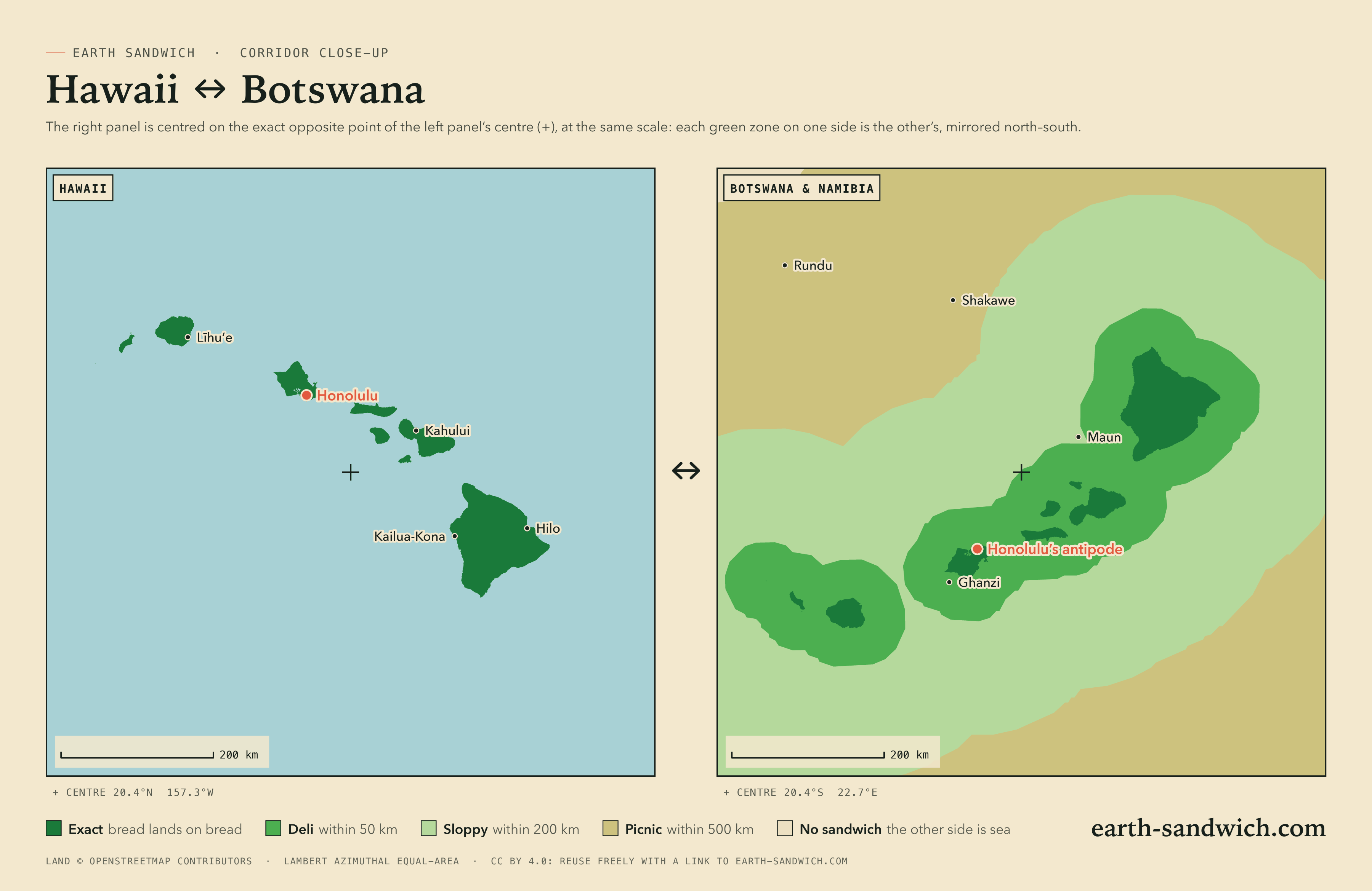
Almost all of the United States faces the Indian Ocean. Hawaii is the great exception: every main island has a twin of the same shape, upside down, in the Kalahari of Botswana, so all 1.4 million people in Hawaii live on a spot where an exact Earth sandwich is possible. The difficulty is the other end. The Kalahari twins are some of the emptiest land in Africa, and the country’s towns lie just outside them.
How it lines up Every city Town twins The highest Timing Finding a partner
How the two sides line up
Turn the Hawaiian chain upside down, carry it half a world, and it comes down across northern Botswana from the Namibian border to the edge of the Makgadikgadi. Oʻahu lands in Ghanzi district: Honolulu’s antipode is 33 km from Dekar, and central Oʻahu’s, around Wahiawā, just outside it. Kauaʻi lands near Charles Hill, by the Namibian border. Maui lands towards Sehithwa, by Lake Ngami. The Big Island, the largest twin, fills the country between Maun and Gweta: Kailua-Kona faces the bush south of Maun, Hilo lands 61 km from Gweta.
Botswana’s towns sit just off the twins, so from them the sandwich is deli or sloppy rather than exact. Ghanzi is a deli sandwich, 16 km short of Oʻahu’s north shore; Maun, the gateway to the Okavango, is 59 km short. Gaborone misses by 469 km, and Johannesburg by 729 km: from the big cities of southern Africa, the nearest exact spot is in northern Botswana.
Every town, and where its other slice lands
Every Hawaiian town above 5,000 people and every county seat. On the other side, every town in Botswana and Namibia above 5,000 and every district capital, and the cities of South Africa, Zambia, Zimbabwe and Angola whose other slice lands off Hawaii, each listed if it lands within 300 km of land or is a capital or a city of a million. Exact means land opposite land at the town’s own point; where the other slice would get wet, the table gives the nearest spot from which an exact sandwich is possible.
| Place | Verdict | Where the other slice lands |
|---|---|---|
| Botswana | ||
| Gaborone246,325 | SOGGY | North Pacific Ocean, 469 km from dry landNearest exact spot: 470 km away, 87 km from Xumo (Central) |
| MaunNorth-West · 85,350 | SLOPPY | North Pacific Ocean, 59 km from dry landNearest exact spot: 59 km away, 59 km from Maun (North-West) |
| LetlhakaneCentral · 36,404 | SLOPPY | North Pacific Ocean, 179 km from dry landNearest exact spot: 180 km away, 55 km from Gweta (Central) |
| Ghanzi19,012 | DELI | North Pacific Ocean, 16 km from dry landNearest exact spot: 28 km away, near Dekar (Ghanzi) |
| TutumeCentral · 18,582 | SOGGY | North Pacific Ocean, 221 km from dry landNearest exact spot: 221 km away, 74 km from Gweta (Central) |
| GumareNorth-West · 11,572 | SLOPPY | North Pacific Ocean, 175 km from dry landNearest exact spot: 175 km away, 61 km from Sehithwa (North-West) |
| ShakaweNorth-West · 10,589 | SOGGY | North Pacific Ocean, 250 km from dry landNearest exact spot: 250 km away, 113 km from Linyanti (Zambezi Region, Namibia) |
| KasaneChobe · 9,143 | SLOPPY | North Pacific Ocean, 152 km from dry landNearest exact spot: 152 km away, 99 km from Linyanti (Zambezi Region, Namibia) |
| OrapaCentral · 8,648 | SLOPPY | North Pacific Ocean, 154 km from dry landNearest exact spot: 160 km away, 56 km from Gweta (Central) |
| NataCentral · 7,779 | SLOPPY | North Pacific Ocean, 129 km from dry landNearest exact spot: 129 km away, 74 km from Gweta (Central) |
| KangKgalagadi · 6,764 | SOGGY | North Pacific Ocean, 232 km from dry landNearest exact spot: 232 km away, near Dekar (Ghanzi) |
| MasungaNorth-East · 6,216 | SOGGY | North Pacific Ocean, 266 km from dry landNearest exact spot: 266 km away, 74 km from Gweta (Central) |
| MaitengweNorth-East · 5,929 | SOGGY | North Pacific Ocean, 222 km from dry landNearest exact spot: 222 km away, 74 km from Gweta (Central) |
| MathangwaneCentral · 5,918 | SOGGY | North Pacific Ocean, 277 km from dry landNearest exact spot: 282 km away, 50 km from Gweta (Central) |
| GwetaCentral · 5,548 | DELI | North Pacific Ocean, 49 km from dry landNearest exact spot: 49 km away, 49 km from Gweta (Central) |
| ChadibeCentral · 5,371 | SOGGY | North Pacific Ocean, 283 km from dry landNearest exact spot: 287 km away, 50 km from Gweta (Central) |
| HukuntsiKgalagadi · 5,224 | SOGGY | North Pacific Ocean, 231 km from dry landNearest exact spot: 231 km away, 62 km from Charles Hill (Ghanzi) |
| Charles HillGhanzi · 5,164 | DELI | North Pacific Ocean, 24 km from dry landNearest exact spot: 24 km away, near Charles Hill (Ghanzi) |
| Namibia | ||
| WindhoekKhomas Region · 386,219 | SLOPPY | North Pacific Ocean, 116 km from dry landNearest exact spot: 327 km away, 30 km from Charles Hill (Ghanzi, Botswana) |
| Walvis BayErongo Region · 73,598 | SLOPPY | North Pacific Ocean, 103 km from dry landNearest exact spot: 595 km away, 30 km from Charles Hill (Ghanzi, Botswana) |
| SwakopmundErongo Region · 53,009 | SLOPPY | North Pacific Ocean, 127 km from dry landNearest exact spot: 589 km away, 30 km from Charles Hill (Ghanzi, Botswana) |
| RehobothHardap Region · 34,185 | SLOPPY | North Pacific Ocean, 105 km from dry landNearest exact spot: 351 km away, 30 km from Charles Hill (Ghanzi, Botswana) |
| Katima MuliloZambezi Region · 33,615 | SLOPPY | North Pacific Ocean, 156 km from dry landNearest exact spot: 156 km away, 99 km from Linyanti (Zambezi Region) |
| OkahandjaOtjozondjupa Region · 26,832 | SLOPPY | North Pacific Ocean, 170 km from dry landNearest exact spot: 341 km away, 30 km from Charles Hill (Ghanzi, Botswana) |
| GrootfonteinOtjozondjupa Region · 24,099 | SOGGY | North Pacific Ocean, 271 km from dry landNearest exact spot: 349 km away, 34 km from Charles Hill (Ghanzi, Botswana) |
| GobabisOmaheke Region · 22,639 | SLOPPY | North Pacific Ocean, 102 km from dry landNearest exact spot: 136 km away, 30 km from Charles Hill (Ghanzi, Botswana) |
| MarientalHardap Region · 14,789 | SLOPPY | North Pacific Ocean, 174 km from dry landNearest exact spot: 363 km away, near Charles Hill (Ghanzi, Botswana) |
| OmaruruErongo Region · 11,547 | SOGGY | North Pacific Ocean, 248 km from dry landNearest exact spot: 447 km away, 34 km from Charles Hill (Ghanzi, Botswana) |
| UsakosErongo Region · 9,147 | SLOPPY | North Pacific Ocean, 177 km from dry landNearest exact spot: 477 km away, 30 km from Charles Hill (Ghanzi, Botswana) |
| OtjimbingweErongo Region · 7,677 | SLOPPY | North Pacific Ocean, 160 km from dry landNearest exact spot: 422 km away, 30 km from Charles Hill (Ghanzi, Botswana) |
| KaribibErongo Region · 6,898 | SLOPPY | North Pacific Ocean, 191 km from dry landNearest exact spot: 451 km away, 34 km from Charles Hill (Ghanzi, Botswana) |
| ArandisErongo Region · 6,127 | SLOPPY | North Pacific Ocean, 133 km from dry landNearest exact spot: 541 km away, 30 km from Charles Hill (Ghanzi, Botswana) |
| OsireOtjozondjupa Region · 5,941 | SOGGY | North Pacific Ocean, 226 km from dry landNearest exact spot: 314 km away, 34 km from Charles Hill (Ghanzi, Botswana) |
| Henties BayErongo Region · 5,594 | SLOPPY | North Pacific Ocean, 176 km from dry landNearest exact spot: 611 km away, 30 km from Charles Hill (Ghanzi, Botswana) |
| OkakararaOtjozondjupa Region · 5,581 | SOGGY | North Pacific Ocean, 238 km from dry landNearest exact spot: 327 km away, 34 km from Charles Hill (Ghanzi, Botswana) |
| South Africa | ||
| JohannesburgGauteng · 9,418,183 | SOGGY | North Pacific Ocean, 729 km from dry landNearest exact spot: 730 km away, 75 km from Xumo (Central, Botswana) |
| Cape TownWestern Cape · 4,772,846 | SOGGY | North Pacific Ocean, 1,171 km from dry landNearest exact spot: 1,318 km away, 30 km from Charles Hill (Ghanzi, Botswana) |
| DurbanKwaZulu-Natal · 3,338,026 | SOGGY | North Pacific Ocean, 1,230 km from dry landNearest exact spot: 1,231 km away, 75 km from Xumo (Central, Botswana) |
| PretoriaGauteng · 2,112,693 | SOGGY | North Pacific Ocean, 697 km from dry landNearest exact spot: 698 km away, 75 km from Xumo (Central, Botswana) |
| GqeberhaEastern Cape · 1,050,078 | SOGGY | North Pacific Ocean, 1,393 km from dry landNearest exact spot: 1,395 km away, 59 km from Charles Hill (Ghanzi, Botswana) |
| Zimbabwe | ||
| Harare1,542,813 | SOGGY | North Pacific Ocean, 645 km from dry landNearest exact spot: 645 km away, 74 km from Gweta (Central, Botswana) |
| LupaneMatabeleland North · 2,211 | SOGGY | North Pacific Ocean, 282 km from dry landNearest exact spot: 282 km away, 74 km from Gweta (Central, Botswana) |
| Zambia | ||
| LusakaLusaka Province · 2,212,301 | SOGGY | North Pacific Ocean, 559 km from dry landNearest exact spot: 559 km away, 97 km from Gweta (Central, Botswana) |
| LivingstoneSouthern Province · 178,361 | SLOPPY | North Pacific Ocean, 189 km from dry landNearest exact spot: 189 km away, 97 km from Gweta (Central, Botswana) |
Town twins
No Hawaiian town has a town within a kilometre of its antipode: the Kalahari twins are bush, farms and villages too small for GeoNames’ list. Every Hawaiian town is still exact, so the sandwich is made by driving to the right spot on the Botswana side.
The highest sandwiches
A sandwich’s elevation bonus is the height of one end plus the height of the other (Sandwich Law § 1.4). The Board scores it the way the map shows it: from the average height of the ground over cells about 20 km across, so every spot in a cell scores the same and you only need to be in the right cell, not on the summit. These are the corridor’s best cells, one per area, each with dry land at both ends.
- +3,840 m29 km from Volcano (Hawaii)cell average 2,920 m108 km from Gweta (Central)cell average 920 m
- +2,240 m6 km from Kēōkea (Hawaii)cell average 1,240 m85 km from Maun (North-West)cell average 1,000 m
- +1,840 m13 km from Wailua Homesteads (Hawaii)cell average 600 m46 km from Charles Hill (Ghanzi)cell average 1,240 m
- +1,600 m9 km from Waimea (Hawaii)cell average 680 m93 km from Maun (North-West)cell average 920 m
- +1,440 m4 km from Schofield Barracks (Hawaii)cell average 280 m5 km from Dekar (Ghanzi)cell average 1,160 m
The Big Island does the work: the best cell, on the slopes above Volcano, averages 2,920 m, and its twin in the Kalahari near Gweta 920 m. The Kalahari itself is a high plateau, which is why even the Botswana ends add close to a kilometre.
Timing it
The window. Both slices must go down within five minutes of the same UTC instant (Sandwich Law § 2.1). The sandwich lobby holds you to it: when the first slice lands, the other side has five minutes.
The clocks. Hawaii keeps UTC−10 and Botswana and Namibia UTC+2, and none of them change their clocks: Gaborone is always exactly 12 hours ahead of Honolulu. Noon in Hawaii is midnight in the Kalahari.
The light. Two exactly opposite points are never in daylight together: sunrise at one end is sunset at the other. The atmosphere bends a little sunlight over the horizon, so twice a day, on a clear flat horizon, the sun is up at both ends at once for about seven to eight minutes. Put the bread down then and both photographs get golden light, one at dusk and one at dawn.
The seasons. Opposite, though Hawaii barely notices. The Kalahari summer, from about November to March, is hot and brings the rain; its winter nights can be cold.
Finding the other slice
The geometry is the easy part; the hard part is a person at the other end, and the site does not match strangers. English is spoken on both sides, which helps. The Botswana end is best reached from Ghanzi and Maun, both of which have lodges, guides and people who know the tracks.
Then open an attempt in the sandwich lobby. It gives you a code and a link to send through whatever channel you already share, shows both slices when they arrive, and runs the five-minute window. Much of the Kalahari side is farmland, communal land or protected area, so ask before you walk in, and carry water. The exact grade allows a kilometre of slack, which is usually enough to find somewhere you are allowed to stand.
City antipodes on this corridor
How this was worked out: towns, populations and their centre points from GeoNames (a place within 20 km of one three times its size is left out as its suburb); land or sea from the OpenStreetMap coastline the map uses; verdicts at each place’s own point, nearest exact spots and elevation bonuses from the same coastline and the verifier’s 0.2° grid (Natural Earth land, ETOPO 2022 relief); sea names and borders from Natural Earth; the share of people with land opposite from GHS-POP 2020 (European Commission, Joint Research Centre, CC BY 4.0), at about 1 km resolution. Clock and daylight figures are for exactly opposite points on a sphere with standard refraction. Generated 2026-09-29.