Earth Sandwich / Corridors / Okinawa & Jeju ↔ southern Brazil
Corridor guide · Okinawa, Amami & Jeju ↔ southern Brazil & Paraguay
Japan isn’t
opposite Brazil.
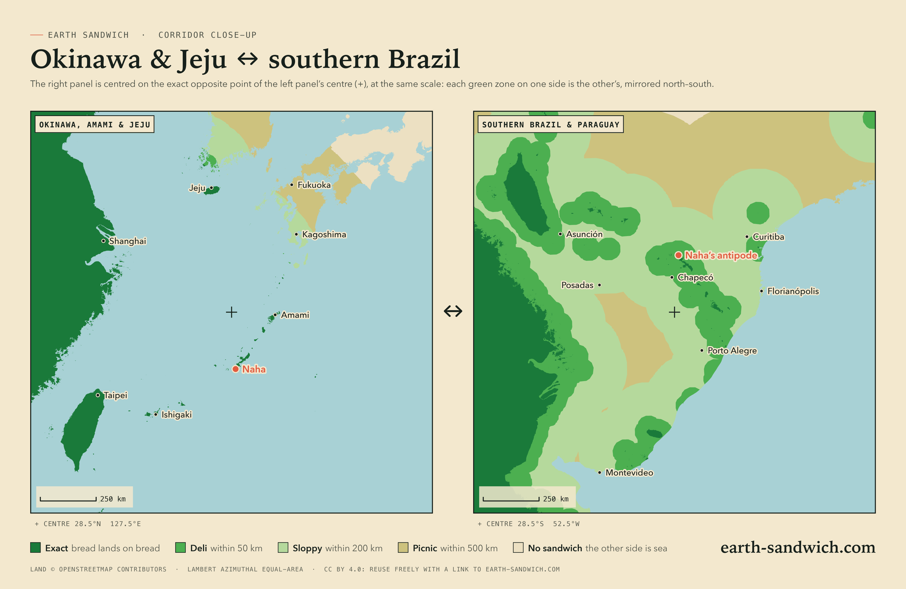
It is one of the best-known facts about antipodes, and it is mostly wrong: Tokyo’s other slice would land in the South Atlantic, 1,096 km from the nearest dry land. But the islands south of Kyushu do reach Brazil. Okinawa, the Amami and Yaeyama islands, and Korea’s Jeju lie exactly opposite southern Brazil and eastern Paraguay: Naha lands 10 km from Honório Serpa, in Paraná, and Jeju City 10 km from Santa Vitória do Palmar, near the Uruguayan border.
How it lines up Every city Town twins The highest Timing Finding a partner
How the two sides line up
Okinawa Island lands in south-western Paraná: Naha near Honório Serpa, Okinawa City near Clevelândia, Uruma and Nago near Palmas. The Amami islands fall on the highlands of Rio Grande do Sul and Santa Catarina, Amami itself near Bom Jesus and Tokunoshima near Cerro Negro. The Miyako and Yaeyama islands reach eastern Paraguay: Ishigaki lands 21 km from Curuguaty, in Canindeyú. Korea’s Jeju comes down in the far south of Brazil, by the lagoons near the Uruguayan border.
And the rest of Japan? Kyushu faces the Atlantic off Rio Grande do Sul, and Tokyo, Osaka and the main cities are hundreds of kilometres further out. From Tokyo the nearest exact spot is in the islands south of Kyushu, 1,122 km away; from Sapporo it is on Sakhalin, whose twin is South Georgia. Seoul and Busan miss too, and so do Brazil’s big cities: São Paulo faces the Philippine Sea, 243 km from land, and Curitiba is a sloppy sandwich, 66 km short.
Every city, and where its other slice lands
Every Japanese city above 700,000 people and every Korean city above a million, with every town of Okinawa, Amami, Miyako and the Yaeyamas above 10,000 and every town of Jeju. On the other side, the cities of southern Brazil above 150,000 and the state capitals, and the cities of Paraguay, Uruguay and north-eastern Argentina, each listed if its other slice lands in or off Japan or Korea within 150 km of land, or it is a capital or a city of a million. Exact means land opposite land at the city’s own point; where the other slice would get wet, the table gives the nearest spot from which an exact sandwich is possible.
| Place | Verdict | Where the other slice lands |
|---|---|---|
| Japan | ||
| Tokyo9,733,276 | SOGGY | South Atlantic Ocean, 1,096 km from dry landNearest exact spot: 1,122 km away, 70 km from Kurio (Kagoshima) |
| YokohamaKanagawa · 3,777,491 | SOGGY | South Atlantic Ocean, 1,080 km from dry landNearest exact spot: 1,103 km away, 70 km from Kurio (Kagoshima) |
| Osaka2,753,862 | SOGGY | South Atlantic Ocean, 708 km from dry landNearest exact spot: 754 km away, 70 km from Kurio (Kagoshima) |
| NagoyaAichi · 2,332,176 | SOGGY | South Atlantic Ocean, 846 km from dry landNearest exact spot: 885 km away, 70 km from Kurio (Kagoshima) |
| SapporoHokkaido · 1,973,832 | SOGGY | South Atlantic Ocean, 1,191 km from dry landNearest exact spot: 1,226 km away, 59 km from Okha (Sakhalin Oblast, Russia) |
| Fukuoka1,612,392 | SOGGY | South Atlantic Ocean, 273 km from dry landNearest exact spot: 321 km away, 33 km from Ponggae-dong (Jeju-do, South Korea) |
| KobeHyōgo · 1,525,152 | SOGGY | South Atlantic Ocean, 684 km from dry landNearest exact spot: 733 km away, 70 km from Kurio (Kagoshima) |
| Kyoto1,463,723 | SOGGY | South Atlantic Ocean, 747 km from dry landNearest exact spot: 796 km away, 70 km from Kurio (Kagoshima) |
| Saitama1,324,854 | SOGGY | South Atlantic Ocean, 1,104 km from dry landNearest exact spot: 1,133 km away, 70 km from Kurio (Kagoshima) |
| Hiroshima1,200,754 | SOGGY | South Atlantic Ocean, 469 km from dry landNearest exact spot: 517 km away, 33 km from Ponggae-dong (Jeju-do, South Korea) |
| SendaiMiyagi · 1,096,704 | SOGGY | South Atlantic Ocean, 1,326 km from dry landNearest exact spot: 1,359 km away, 33 km from Ponggae-dong (Jeju-do, South Korea) |
| Chiba979,768 | SOGGY | South Atlantic Ocean, 1,126 km from dry landNearest exact spot: 1,149 km away, 70 km from Kurio (Kagoshima) |
| KitakyushuFukuoka · 940,978 | SOGGY | South Atlantic Ocean, 321 km from dry landNearest exact spot: 363 km away, 33 km from Ponggae-dong (Jeju-do, South Korea) |
| Niigata797,591 | SOGGY | South Atlantic Ocean, 1,173 km from dry landNearest exact spot: 1,196 km away, 33 km from Ponggae-dong (Jeju-do, South Korea) |
| HamamatsuShizuoka · 791,707 | SOGGY | South Atlantic Ocean, 887 km from dry landNearest exact spot: 913 km away, 70 km from Kurio (Kagoshima) |
| Kumamoto738,907 | SOGGY | South Atlantic Ocean, 229 km from dry landNearest exact spot: 335 km away, 70 km from Kurio (Kagoshima) |
| AiharaKanagawa · 725,493 | SOGGY | South Atlantic Ocean, 1,061 km from dry landNearest exact spot: 1,088 km away, 70 km from Kurio (Kagoshima) |
| Okayama724,691 | SOGGY | South Atlantic Ocean, 589 km from dry landNearest exact spot: 654 km away, 70 km from Kurio (Kagoshima) |
| SagamiharaKanagawa · 720,780 | SOGGY | South Atlantic Ocean, 1,053 km from dry landNearest exact spot: 1,080 km away, 70 km from Kurio (Kagoshima) |
| NahaOkinawa · 317,625 | EXACT | Dry land 10 km from Honório Serpa (Paraná) |
| Okinawa142,752 | EXACT | Dry land 17 km from Clevelândia (Paraná) |
| UrumaOkinawa · 125,303 | EXACT | Dry land 19 km from Palmas (Paraná) |
| UrasoeOkinawa · 115,690 | EXACT | Dry land 18 km from Honório Serpa (Paraná) |
| GushikawaOkinawa · 65,251 | EXACT | Dry land 18 km from Coronel Domingos Soares (Paraná) |
| NagoOkinawa · 63,554 | EXACT | Dry land 15 km from Palmas (Paraná) |
| MiyakojimaOkinawa · 54,908 | EXACT | Dry land 26 km from Minga Porá (Alto Paraná Department, Paraguay) |
| IshigakiOkinawa · 47,637 | EXACT | Dry land 21 km from San Isidro de Curuguaty (Canindeyú, Paraguay) |
| AmamiKagoshima · 41,390 | EXACT | Dry land 34 km from Bom Jesus (Rio Grande do Sul) |
| HiraraOkinawa · 34,354 | EXACT | Dry land 25 km from Minga Porá (Alto Paraná Department, Paraguay) |
| TokuwaseKagoshima · 10,147 | EXACT | Dry land 10 km from Cerro Negro (Santa Catarina) |
| South Korea | ||
| Seoul10,349,312 | SOGGY | South Atlantic Ocean, 327 km from dry landNearest exact spot: 338 km away, near Sinan (Jeollanam-do) |
| Busan3,285,147 | SOGGY | South Atlantic Ocean, 261 km from dry landNearest exact spot: 261 km away, 33 km from Ponggae-dong (Jeju-do) |
| Incheon3,015,482 | SOGGY | South Atlantic Ocean, 305 km from dry landNearest exact spot: 320 km away, near Sinan (Jeollanam-do) |
| Daegu2,365,523 | SOGGY | South Atlantic Ocean, 268 km from dry landNearest exact spot: 271 km away, 40 km from Haenam (Jeollanam-do) |
| Daejeon1,441,203 | SOGGY | South Atlantic Ocean, 233 km from dry landNearest exact spot: 233 km away, near Sinan (Jeollanam-do) |
| Gwangju1,401,235 | SLOPPY | South Atlantic Ocean, 103 km from dry landNearest exact spot: 105 km away, 40 km from Haenam (Jeollanam-do) |
| SuwonGyeonggi-do · 1,234,582 | SOGGY | South Atlantic Ocean, 303 km from dry landNearest exact spot: 310 km away, near Sinan (Jeollanam-do) |
| Ulsan1,098,421 | SOGGY | South Atlantic Ocean, 307 km from dry landNearest exact spot: 310 km away, 40 km from Haenam (Jeollanam-do) |
| ChangwonGyeongsangnam-do · 1,025,702 | SOGGY | South Atlantic Ocean, 240 km from dry landNearest exact spot: 244 km away, 40 km from Haenam (Jeollanam-do) |
| Jeju CityJeju-do · 488,844 | EXACT | Dry land 10 km from Santa Vitória do Palmar (Rio Grande do Sul) |
| SeogwipoJeju-do · 178,552 | EXACT | Dry land 30 km from Santa Vitória do Palmar (Rio Grande do Sul) |
| Place | Verdict | Where the other slice lands |
|---|---|---|
| Brazil | ||
| São Paulo12,400,232 | SOGGY | Philippine Sea, 243 km from dry landNearest exact spot: 331 km away, near Guaratuba (Paraná) |
| CuritibaParaná · 1,948,626 | SLOPPY | Philippine Sea, 66 km from dry landNearest exact spot: 66 km away, near Guaratuba (Paraná) |
| Porto AlegreRio Grande do Sul · 1,488,252 | SLOPPY | East China Sea, 74 km from dry landNearest exact spot: 98 km away, near Maquiné (Rio Grande do Sul) |
| CampinasSão Paulo · 1,031,554 | SOGGY | Philippine Sea, 248 km from dry landNearest exact spot: 366 km away, near Guaratuba (Paraná) |
| JoinvilleSanta Catarina · 664,500 | DELI | Philippine Sea, 42 km from dry landNearest exact spot: 42 km away, near Guaratuba (Paraná) |
| Caxias do SulRio Grande do Sul · 479,599 | DELI | East China Sea, 37 km from dry landNearest exact spot: 102 km away, near Vacaria (Rio Grande do Sul) |
| CascavelParaná · 368,195 | SLOPPY | Philippine Sea, 112 km from dry landNearest exact spot: 117 km away, near Santa Helena (Paraná) |
| BlumenauSanta Catarina · 361,261 | SLOPPY | Philippine Sea, 114 km from dry landNearest exact spot: 114 km away, near Guaratuba (Paraná) |
| PelotasRio Grande do Sul · 336,150 | SLOPPY | East China Sea, 67 km from dry landNearest exact spot: 188 km away, near Santa Vitória do Palmar (Rio Grande do Sul) |
| Foz do IguaçuParaná · 297,352 | SLOPPY | East China Sea, 63 km from dry landNearest exact spot: 84 km away, near Minga Porá (Alto Paraná Department, Paraguay) |
| ItajaíSanta Catarina · 294,850 | SLOPPY | Philippine Sea, 106 km from dry landNearest exact spot: 106 km away, near Guaratuba (Paraná) |
| ChapecóSanta Catarina · 282,648 | SLOPPY | East China Sea, 54 km from dry landNearest exact spot: 58 km away, near Ouro Verde (Santa Catarina) |
| GravataíRio Grande do Sul · 265,074 | SLOPPY | East China Sea, 51 km from dry landNearest exact spot: 73 km away, near Maquiné (Rio Grande do Sul) |
| Novo HamburgoRio Grande do Sul · 253,841 | SLOPPY | East China Sea, 63 km from dry landNearest exact spot: 79 km away, near Maquiné (Rio Grande do Sul) |
| ViamãoRio Grande do Sul · 231,996 | SLOPPY | East China Sea, 56 km from dry landNearest exact spot: 83 km away, near Maquiné (Rio Grande do Sul) |
| DivinópolisMinas Gerais · 231,091 | SLOPPY | Philippine Sea, 105 km from dry landNearest exact spot: 744 km away, near Guaratuba (Paraná) |
| CriciúmaSanta Catarina · 227,438 | SLOPPY | Philippine Sea, 68 km from dry landNearest exact spot: 105 km away, near Bom Jesus (Rio Grande do Sul) |
| Passo FundoRio Grande do Sul · 214,811 | SLOPPY | East China Sea, 75 km from dry landNearest exact spot: 134 km away, near Pinhal da Serra (Rio Grande do Sul) |
| São LeopoldoRio Grande do Sul · 209,229 | SLOPPY | East China Sea, 65 km from dry landNearest exact spot: 81 km away, near Maquiné (Rio Grande do Sul) |
| São JoséSanta Catarina · 200,000 | SLOPPY | Philippine Sea, 82 km from dry landNearest exact spot: 123 km away, 32 km from Bom Jesus (Rio Grande do Sul) |
| Rio GrandeRio Grande do Sul · 198,935 | DELI | East China Sea, 30 km from dry landNearest exact spot: 173 km away, near Santa Vitória do Palmar (Rio Grande do Sul) |
| GuarapuavaParaná · 189,630 | SLOPPY | Philippine Sea, 107 km from dry landNearest exact spot: 112 km away, near Honório Serpa (Paraná) |
| Jaraguá do SulSanta Catarina · 182,660 | SLOPPY | Philippine Sea, 70 km from dry landNearest exact spot: 70 km away, near Guaratuba (Paraná) |
| IbiritéMinas Gerais · 179,582 | DELI | Philippine Sea, 47 km from dry landNearest exact spot: 804 km away, near Guaratuba (Paraná) |
| LagesSanta Catarina · 172,458 | DELI | Philippine Sea, 44 km from dry landNearest exact spot: 44 km away, near Capão Alto (Santa Catarina) |
| ItapetiningaSão Paulo · 164,256 | SLOPPY | Philippine Sea, 124 km from dry landNearest exact spot: 257 km away, near Guaratuba (Paraná) |
| AraucáriaParaná · 162,247 | SLOPPY | Philippine Sea, 67 km from dry landNearest exact spot: 67 km away, near Guaratuba (Paraná) |
| ToledoParaná · 160,701 | SLOPPY | Philippine Sea, 80 km from dry landNearest exact spot: 87 km away, 31 km from Santa Helena (Paraná) |
| BrusqueSanta Catarina · 155,307 | SLOPPY | Philippine Sea, 130 km from dry landNearest exact spot: 130 km away, near Guaratuba (Paraná) |
| ParanaguáParaná · 150,104 | DELI | Philippine Sea, 40 km from dry landNearest exact spot: 40 km away, near Guaratuba (Paraná) |
| Paraguay | ||
| Ciudad del EsteAlto Paraná Department · 301,815 | SLOPPY | East China Sea, 58 km from dry landNearest exact spot: 78 km away, near Minga Porá (Alto Paraná Department) |
| CaacupéCordillera Department · 56,864 | SLOPPY | East China Sea, 72 km from dry landNearest exact spot: 102 km away, near Puerto Rosario (San Pedro Department) |
| CaaguazúCaaguazú Department · 54,808 | SLOPPY | East China Sea, 51 km from dry landNearest exact spot: 111 km away, near San Isidro de Curuguaty (Canindeyú) |
| Coronel OviedoCaaguazú Department · 51,286 | DELI | East China Sea, 30 km from dry landNearest exact spot: 122 km away, near General Elizardo Aquino (San Pedro Department) |
| VillarricaGuairá · 41,157 | DELI | East China Sea, under 1 km from dry landNearest exact spot: 153 km away, near General Elizardo Aquino (San Pedro Department) |
| Caazapá23,996 | DELI | East China Sea, 30 km from dry landNearest exact spot: 199 km away, near San Isidro de Curuguaty (Canindeyú) |
| San Juan BautistaMisiones Department · 16,593 | SLOPPY | East China Sea, 116 km from dry landNearest exact spot: 195 km away, near Laguna Naick-Neck (Formosa, Argentina) |
| San Pedro de YcuamandyyúSan Pedro Department · 11,548 | DELI | Philippine Sea, 40 km from dry landNearest exact spot: 40 km away, near Puerto Rosario (San Pedro Department) |
| Paraguarí10,079 | SLOPPY | East China Sea, 62 km from dry landNearest exact spot: 109 km away, near Laguna Naick-Neck (Formosa, Argentina) |
| Salto del GuairáCanindeyú · 7,385 | SLOPPY | Philippine Sea, 76 km from dry landNearest exact spot: 79 km away, 31 km from Santa Helena (Paraná, Brazil) |
| Uruguay | ||
| MontevideoMontevideo Department · 1,270,737 | SLOPPY | Yellow Sea, 127 km from dry landNearest exact spot: 207 km away, near Costa Azul (Rocha Department) |
| Maldonado102,000 | DELI | Yellow Sea, 25 km from dry landNearest exact spot: 102 km away, near Costa Azul (Rocha Department) |
| MeloCerro Largo · 56,013 | SLOPPY | East China Sea, 92 km from dry landNearest exact spot: 102 km away, near General Enrique Martínez (Rocha Department) |
| MinasLavalleja · 38,645 | DELI | Yellow Sea, 41 km from dry landNearest exact spot: 114 km away, near Costa Azul (Rocha Department) |
| Florida36,471 | SLOPPY | Yellow Sea, 119 km from dry landNearest exact spot: 207 km away, near Costa Azul (Rocha Department) |
| Barros BlancosCanelones · 31,650 | SLOPPY | Yellow Sea, 108 km from dry landNearest exact spot: 187 km away, near Costa Azul (Rocha Department) |
| RochaRocha Department · 26,784 | DELI | Yellow Sea, 5 km from dry landNearest exact spot: 31 km away, near Costa Azul (Rocha Department) |
| Treinta y TresTreinta y Tres Department · 25,890 | SLOPPY | Yellow Sea, 52 km from dry landNearest exact spot: 55 km away, near Cebollatí (Rocha Department) |
| Canelones24,185 | SLOPPY | Yellow Sea, 133 km from dry landNearest exact spot: 210 km away, near Costa Azul (Rocha Department) |
Town twins
No two towns here are within a kilometre of each other’s antipode, but every town in Okinawa and Jeju is exact, and several land within a few kilometres of a Brazilian or Paraguayan town. Naha and Honório Serpa, and Jeju City and Santa Vitória do Palmar, are about ten kilometres apart.
The highest sandwiches
A sandwich’s elevation bonus is the height of one end plus the height of the other (Sandwich Law § 1.4). The Board scores it the way the map shows it: from the average height of the ground over cells about 20 km across, so every spot in a cell scores the same and you only need to be in the right cell, not on the summit. These are the corridor’s best cells, one per area, each with dry land at both ends.
- +1,040 m8 km from Naze (Kagoshima)cell average 40 m40 km from Capão Alto (Santa Catarina)cell average 1,000 m
- +960 m5 km from Onna (Okinawa)cell average -40 m11 km from Palmas (Paraná)cell average 1,000 m
- +480 m8 km from Seogwipo (Jeju-do, South Korea)cell average 520 m27 km from Santa Vitória do Palmar (Rio Grande do Sul)cell average -40 m
- +240 m17 km from Shirahama (Okinawa)cell average 40 m40 km from Guajayvi (San Pedro Department, Paraguay)cell average 200 m
This is the lowest corridor: Okinawa’s hills are gentle and the islands’ cells are mostly sea level. The height comes from the Brazilian end, where the Serra Geral of Santa Catarina and Paraná rises to about a kilometre.
Timing it
The window. Both slices must go down within five minutes of the same UTC instant (Sandwich Law § 2.1). The sandwich lobby holds you to it: when the first slice lands, the other side has five minutes.
The clocks. Japan and Korea keep UTC+9; southern Brazil keeps Brasília time, UTC−3, and so do Paraguay and Uruguay. Nobody changes their clocks, so the gap is 12 hours all year: noon in Naha is midnight in Paraná.
The light. Two exactly opposite points are never in daylight together: sunrise at one end is sunset at the other. The atmosphere bends a little sunlight over the horizon, so twice a day, on a clear flat horizon, the sun is up at both ends at once for eight to nine minutes. Put the bread down then and both photographs get golden light, one at dusk and one at dawn.
The seasons. Opposite. Okinawa’s typhoons come in late summer and autumn; the Brazilian highlands where it lands can see frost in July.
Finding the other slice
This corridor has something no other has: a community already on both sides. Brazil is home to the largest Japanese community outside Japan, Paraná is one of its heartlands, and many Japanese-Brazilian families have roots in Okinawa. Write in Japanese and Portuguese, with your town and its antipode; Okinawan and Japanese associations in Brazil are a natural place to start.
Then open an attempt in the sandwich lobby. It gives you a code and a link to send through whatever channel you already share, shows both slices when they arrive, and runs the five-minute window. Much of the Brazilian side is farmland, so put the bread on public ground, a roadside, a square or a park, or ask whoever owns the field. The exact grade allows a kilometre of slack, which is usually enough to find somewhere you are allowed to stand.
City antipodes on this corridor
How this was worked out: towns, populations and their centre points from GeoNames (a place within 20 km of one three times its size is left out as its suburb); land or sea from the OpenStreetMap coastline the map uses; verdicts at each place’s own point, nearest exact spots and elevation bonuses from the same coastline and the verifier’s 0.2° grid (Natural Earth land, ETOPO 2022 relief); sea names and borders from Natural Earth; the share of people with land opposite from GHS-POP 2020 (European Commission, Joint Research Centre, CC BY 4.0), at about 1 km resolution. Clock and daylight figures are for exactly opposite points on a sphere with standard refraction. Generated 2026-09-29.