Earth Sandwich / Corridors / The US & Canada ↔ the southern Indian Ocean
Corridor guide · The US & Canada ↔ Kerguelen, Heard & Amsterdam
America’s other
side is ocean.
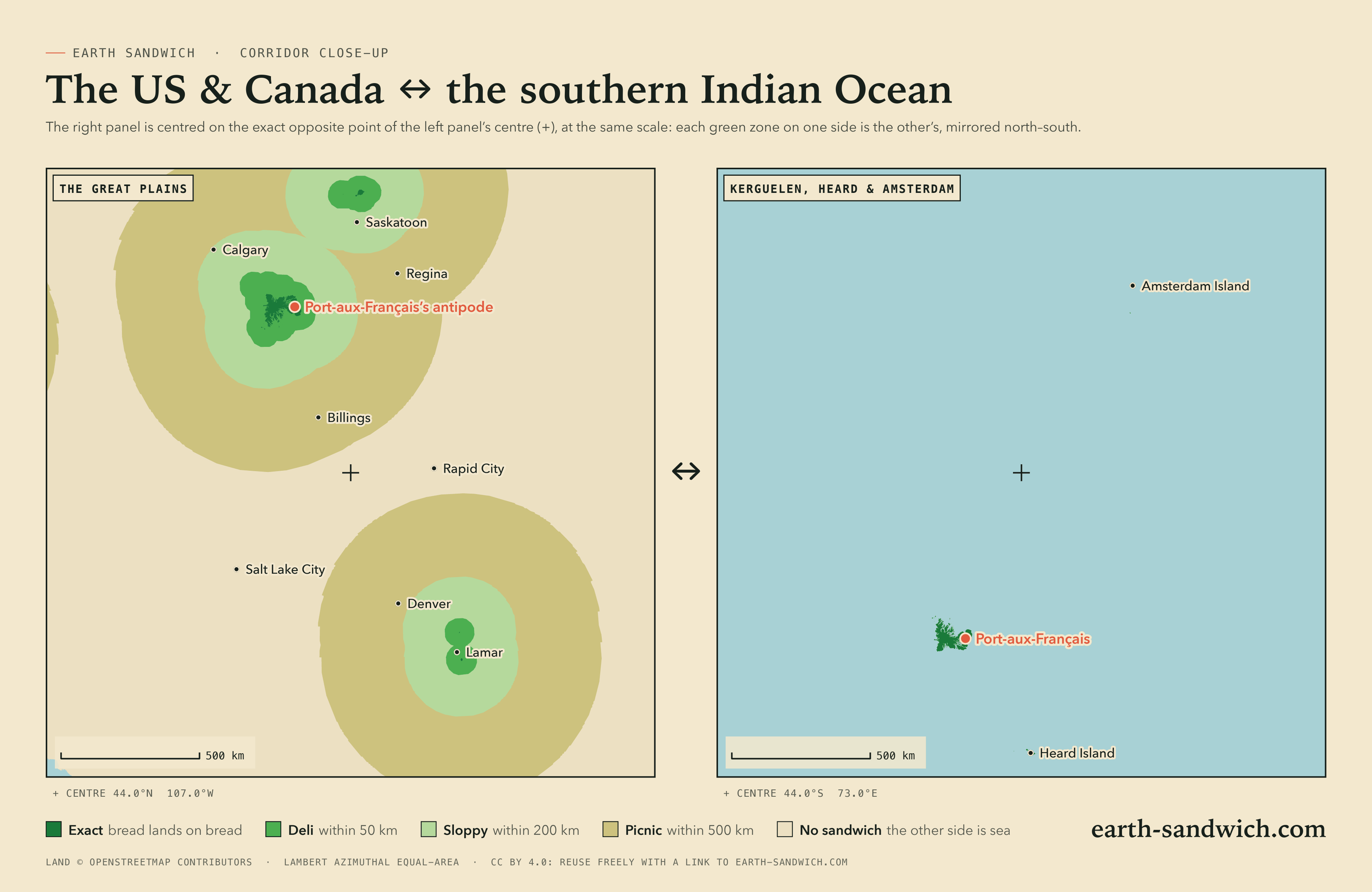
Put a slice of bread down in New York and the other would land in the Indian Ocean, 1,068 km south-west of Australia. Almost the whole of the United States and Canada is like that. Not quite all, though: three islands in the far south of the Indian Ocean have their twins on the Great Plains. Kerguelen lies opposite the borderlands of Saskatchewan, Alberta and Montana, Heard Island opposite the farmland near Prince Albert, and tiny Amsterdam Island opposite south-eastern Colorado.
How it lines up Every city Town twins The highest Timing Finding a partner
How the two sides line up
The three islands are French and Australian territory, and nobody lives on them for good. Kerguelen and Amsterdam have French research stations, Port-aux-Français and Martin-de-Viviès; Heard Island, Australian, has nobody at all. Their twins are prairie and ranch land. Kerguelen’s fills the country where Saskatchewan, Alberta and Montana meet: Port-aux-Français’s antipode is 66 km from Maple Creek. Heard Island’s lies in the farmland near Shellbrook, west of Prince Albert. Amsterdam Island and its neighbour St Paul are specks, and so are their twins, in eastern Colorado near Lamar and Cheyenne Wells.
Everything else misses. New York, Chicago, Los Angeles, Toronto and Montréal all face the open Indian Ocean, a thousand kilometres or more from land; their nearest exact spots are the Colorado and prairie twins. Calgary comes closest of the big cities, a sloppy sandwich 198 km short of Kerguelen; Medicine Hat is a deli one, 16 km short. Bermuda is a deli sandwich too, 37 km off the coast of Western Australia, south of Perth.
The other exceptions have their own guides: Hawaii faces Botswana, and the north of Alaska and the Canadian Arctic face Antarctica.
Every city, and where its other slice lands
Every city of a million people in the United States and Canada, and every provincial capital, with the towns of the northern Great Plains above 20,000 and the smaller towns close to the three twins; each listed if its other slice lands within 200 km of land, or it is a capital or a city of a million. On the other side, the research stations of Kerguelen, Heard and Amsterdam, and Perth. Exact means land opposite land at the place’s own point; where the other slice would get wet, the table gives the nearest spot from which an exact sandwich is possible.
| Place | Verdict | Where the other slice lands |
|---|---|---|
| United States | ||
| New York CityNew York · 8,804,190 | SOGGY | Indian Ocean, 1,068 km from dry landNearest exact spot: 2,454 km away, 34 km from Lamar (Colorado) |
| Los AngelesCalifornia · 3,820,914 | SOGGY | Indian Ocean, 1,477 km from dry landNearest exact spot: 1,477 km away, 30 km from Lamar (Colorado) |
| ChicagoIllinois · 2,664,452 | SOGGY | Indian Ocean, 1,300 km from dry landNearest exact spot: 1,334 km away, 34 km from Lamar (Colorado) |
| HoustonTexas · 2,314,157 | SOGGY | Indian Ocean, 1,107 km from dry landNearest exact spot: 1,108 km away, 34 km from Lamar (Colorado) |
| PhoenixArizona · 1,650,070 | SOGGY | Indian Ocean, 994 km from dry landNearest exact spot: 994 km away, 30 km from Lamar (Colorado) |
| PhiladelphiaPennsylvania · 1,573,916 | SOGGY | Indian Ocean, 1,100 km from dry landNearest exact spot: 2,360 km away, 34 km from Lamar (Colorado) |
| San AntonioTexas · 1,526,656 | SOGGY | Indian Ocean, 1,000 km from dry landNearest exact spot: 1,001 km away, 35 km from Lamar (Colorado) |
| San DiegoCalifornia · 1,404,452 | SOGGY | Indian Ocean, 1,439 km from dry landNearest exact spot: 1,447 km away, 30 km from Lamar (Colorado) |
| DallasTexas · 1,326,087 | SOGGY | Indian Ocean, 757 km from dry landNearest exact spot: 757 km away, 34 km from Lamar (Colorado) |
| JacksonvilleFlorida · 1,009,833 | SOGGY | Indian Ocean, 1,494 km from dry landNearest exact spot: 2,079 km away, 34 km from Lamar (Colorado) |
| Fort WorthTexas · 1,008,106 | SOGGY | Indian Ocean, 731 km from dry landNearest exact spot: 732 km away, 34 km from Lamar (Colorado) |
| WashingtonDistrict of Columbia · 689,545 | SOGGY | Indian Ocean, 1,192 km from dry landNearest exact spot: 2,208 km away, 34 km from Lamar (Colorado) |
| PuebloColorado · 109,412 | SLOPPY | Indian Ocean, 191 km from dry landNearest exact spot: 192 km away, 30 km from Lamar (Colorado) |
| Great FallsMontana · 59,638 | SLOPPY | Indian Ocean, 106 km from dry landNearest exact spot: 131 km away, near Chester (Montana) |
| Garden CityKansas · 27,005 | SLOPPY | Indian Ocean, 135 km from dry landNearest exact spot: 135 km away, 34 km from Lamar (Colorado) |
| LiberalKansas · 20,746 | SLOPPY | Indian Ocean, 158 km from dry landNearest exact spot: 158 km away, 34 km from Lamar (Colorado) |
| HavreMontana · 9,834 | SLOPPY | Indian Ocean, 54 km from dry landNearest exact spot: 56 km away, 56 km from Havre (Montana) |
| LamarColorado · 7,555 | DELI | Indian Ocean, 28 km from dry landNearest exact spot: 28 km away, near Lamar (Colorado) |
| La JuntaColorado · 6,951 | SLOPPY | Indian Ocean, 94 km from dry landNearest exact spot: 94 km away, 30 km from Lamar (Colorado) |
| UlyssesKansas · 6,097 | SLOPPY | Indian Ocean, 97 km from dry landNearest exact spot: 97 km away, 34 km from Lamar (Colorado) |
| HugotonKansas · 3,964 | SLOPPY | Indian Ocean, 119 km from dry landNearest exact spot: 119 km away, 34 km from Lamar (Colorado) |
| Rocky FordColorado · 3,827 | SLOPPY | Indian Ocean, 111 km from dry landNearest exact spot: 111 km away, 30 km from Lamar (Colorado) |
| ShelbyMontana · 3,268 | DELI | Indian Ocean, 37 km from dry landNearest exact spot: 61 km away, near Chester (Montana) |
| Cut BankMontana · 3,002 | SLOPPY | Indian Ocean, 69 km from dry landNearest exact spot: 91 km away, near Chester (Montana) |
| ConradMontana · 2,593 | SLOPPY | Indian Ocean, 63 km from dry landNearest exact spot: 87 km away, near Chester (Montana) |
| Las AnimasColorado · 2,227 | SLOPPY | Indian Ocean, 69 km from dry landNearest exact spot: 69 km away, 30 km from Lamar (Colorado) |
| LakinKansas · 2,202 | SLOPPY | Indian Ocean, 102 km from dry landNearest exact spot: 102 km away, 34 km from Lamar (Colorado) |
| ElkhartKansas · 2,042 | SLOPPY | Indian Ocean, 101 km from dry landNearest exact spot: 101 km away, 35 km from Lamar (Colorado) |
| HookerOklahoma · 1,996 | SLOPPY | Indian Ocean, 151 km from dry landNearest exact spot: 151 km away, 34 km from Lamar (Colorado) |
| MaltaMontana · 1,963 | SLOPPY | Indian Ocean, 144 km from dry landNearest exact spot: 144 km away, 60 km from Chinook (Montana) |
| SyracuseKansas · 1,663 | SLOPPY | Indian Ocean, 59 km from dry landNearest exact spot: 59 km away, 34 km from Lamar (Colorado) |
| LeotiKansas · 1,484 | SLOPPY | Indian Ocean, 99 km from dry landNearest exact spot: 116 km away, 34 km from Lamar (Colorado) |
| SpringfieldColorado · 1,396 | DELI | Indian Ocean, 45 km from dry landNearest exact spot: 46 km away, 35 km from Lamar (Colorado) |
| JohnsonKansas · 1,327 | SLOPPY | Indian Ocean, 65 km from dry landNearest exact spot: 65 km away, 34 km from Lamar (Colorado) |
| Fort Belknap AgencyMontana · 1,293 | SLOPPY | Indian Ocean, 86 km from dry landNearest exact spot: 86 km away, 60 km from Chinook (Montana) |
| ChinookMontana · 1,228 | SLOPPY | Indian Ocean, 60 km from dry landNearest exact spot: 60 km away, 60 km from Chinook (Montana) |
| FowlerColorado · 1,148 | SLOPPY | Indian Ocean, 139 km from dry landNearest exact spot: 139 km away, 30 km from Lamar (Colorado) |
| EllicottColorado · 1,131 | SLOPPY | Indian Ocean, 165 km from dry landNearest exact spot: 200 km away, 30 km from Lamar (Colorado) |
| Canada | ||
| TorontoOntario · 2,794,356 | SOGGY | Indian Ocean, 1,623 km from dry landNearest exact spot: 2,036 km away, 34 km from Lamar (Colorado, United States) |
| MontréalQuebec · 1,762,949 | SOGGY | Indian Ocean, 1,431 km from dry landNearest exact spot: 2,496 km away, near Shellbrook (Saskatchewan) |
| CalgaryAlberta · 1,306,784 | SLOPPY | Indian Ocean, 198 km from dry landNearest exact spot: 252 km away, near Bow Island (Alberta) |
| OttawaOntario · 1,017,449 | SOGGY | Indian Ocean, 1,533 km from dry landNearest exact spot: 2,362 km away, near Shellbrook (Saskatchewan) |
| EdmontonAlberta · 1,010,899 | SOGGY | Indian Ocean, 406 km from dry landNearest exact spot: 453 km away, near Bow Island (Alberta) |
| SaskatoonSaskatchewan · 266,141 | SLOPPY | Indian Ocean, 87 km from dry landNearest exact spot: 97 km away, near Shellbrook (Saskatchewan) |
| LethbridgeAlberta · 103,197 | SLOPPY | Indian Ocean, 74 km from dry landNearest exact spot: 112 km away, 58 km from Bow Island (Alberta) |
| Medicine HatAlberta · 63,138 | DELI | Indian Ocean, 16 km from dry landNearest exact spot: 42 km away, 38 km from Bow Island (Alberta) |
| Prince AlbertSaskatchewan · 35,102 | DELI | Indian Ocean, 26 km from dry landNearest exact spot: 30 km away, near Shellbrook (Saskatchewan) |
| LloydminsterAlberta · 31,582 | SLOPPY | Indian Ocean, 176 km from dry landNearest exact spot: 229 km away, near Shellbrook (Saskatchewan) |
| OkotoksAlberta · 30,214 | SLOPPY | Indian Ocean, 172 km from dry landNearest exact spot: 227 km away, near Bow Island (Alberta) |
| North BattlefordSaskatchewan · 19,440 | SLOPPY | Indian Ocean, 64 km from dry landNearest exact spot: 117 km away, near Shellbrook (Saskatchewan) |
| Swift CurrentSaskatchewan · 16,604 | SLOPPY | Indian Ocean, 150 km from dry landNearest exact spot: 156 km away, 37 km from Maple Creek (Saskatchewan) |
| BrooksAlberta · 14,451 | SLOPPY | Indian Ocean, 69 km from dry landNearest exact spot: 107 km away, near Bow Island (Alberta) |
| WarmanSaskatchewan · 10,961 | SLOPPY | Indian Ocean, 66 km from dry landNearest exact spot: 80 km away, near Shellbrook (Saskatchewan) |
| TaberAlberta · 8,163 | DELI | Indian Ocean, 27 km from dry landNearest exact spot: 68 km away, near Bow Island (Alberta) |
| MelfortSaskatchewan · 5,778 | SLOPPY | Indian Ocean, 104 km from dry landNearest exact spot: 119 km away, near Shellbrook (Saskatchewan) |
| HumboldtSaskatchewan · 4,822 | SLOPPY | Indian Ocean, 118 km from dry landNearest exact spot: 128 km away, near Shellbrook (Saskatchewan) |
| KindersleySaskatchewan · 4,249 | SLOPPY | Indian Ocean, 194 km from dry landNearest exact spot: 202 km away, 31 km from Maple Creek (Saskatchewan) |
| HannaAlberta · 3,140 | SLOPPY | Indian Ocean, 186 km from dry landNearest exact spot: 217 km away, near Bow Island (Alberta) |
| UnitySaskatchewan · 2,475 | SLOPPY | Indian Ocean, 133 km from dry landNearest exact spot: 184 km away, near Shellbrook (Saskatchewan) |
| RosetownSaskatchewan · 2,309 | SLOPPY | Indian Ocean, 168 km from dry landNearest exact spot: 188 km away, near Shellbrook (Saskatchewan) |
| OutlookSaskatchewan · 2,279 | SLOPPY | Indian Ocean, 163 km from dry landNearest exact spot: 171 km away, near Shellbrook (Saskatchewan) |
| Maple CreekSaskatchewan · 2,121 | DELI | Indian Ocean, 31 km from dry landNearest exact spot: 31 km away, 31 km from Maple Creek (Saskatchewan) |
| BiggarSaskatchewan · 2,068 | SLOPPY | Indian Ocean, 113 km from dry landNearest exact spot: 141 km away, near Shellbrook (Saskatchewan) |
| Bow IslandAlberta · 2,025 | DELI | Indian Ocean, 13 km from dry landNearest exact spot: 19 km away, near Bow Island (Alberta) |
| WatrousSaskatchewan · 1,865 | SLOPPY | Indian Ocean, 152 km from dry landNearest exact spot: 168 km away, near Shellbrook (Saskatchewan) |
| ShaunavonSaskatchewan · 1,658 | SLOPPY | Indian Ocean, 80 km from dry landNearest exact spot: 85 km away, 67 km from Maple Creek (Saskatchewan) |
| LanghamSaskatchewan · 1,496 | SLOPPY | Indian Ocean, 70 km from dry landNearest exact spot: 76 km away, near Shellbrook (Saskatchewan) |
| RosthernSaskatchewan · 1,405 | DELI | Indian Ocean, 27 km from dry landNearest exact spot: 41 km away, near Shellbrook (Saskatchewan) |
| WilkieSaskatchewan · 1,301 | SLOPPY | Indian Ocean, 109 km from dry landNearest exact spot: 156 km away, near Shellbrook (Saskatchewan) |
| MacklinSaskatchewan · 1,257 | SLOPPY | Indian Ocean, 186 km from dry landNearest exact spot: 237 km away, near Shellbrook (Saskatchewan) |
| WaldheimSaskatchewan · 1,237 | DELI | Indian Ocean, 35 km from dry landNearest exact spot: 42 km away, near Shellbrook (Saskatchewan) |
| VauxhallAlberta · 1,222 | DELI | Indian Ocean, 21 km from dry landNearest exact spot: 76 km away, near Bow Island (Alberta) |
| BassanoAlberta · 1,206 | SLOPPY | Indian Ocean, 101 km from dry landNearest exact spot: 148 km away, near Bow Island (Alberta) |
| LaniganSaskatchewan · 1,204 | SLOPPY | Indian Ocean, 151 km from dry landNearest exact spot: 163 km away, near Shellbrook (Saskatchewan) |
| ShellbrookSaskatchewan · 1,192 | DELI | Indian Ocean, 4 km from dry landNearest exact spot: 4 km away, near Shellbrook (Saskatchewan) |
| DavidsonSaskatchewan · 1,164 | SLOPPY | Indian Ocean, 184 km from dry landNearest exact spot: 199 km away, near Shellbrook (Saskatchewan) |
| KerrobertSaskatchewan · 1,061 | SLOPPY | Indian Ocean, 169 km from dry landNearest exact spot: 210 km away, near Shellbrook (Saskatchewan) |
| DelisleSaskatchewan · 1,024 | SLOPPY | Indian Ocean, 119 km from dry landNearest exact spot: 125 km away, near Shellbrook (Saskatchewan) |
| Bermuda | ||
| HamiltonHamilton city · 902 | DELI | Geographe Bay, 37 km from dry landNearest exact spot: 2,557 km away, 81 km from Peñal (Penal/Debe, Trinidad and Tobago) |
| Place | Verdict | Where the other slice lands |
|---|---|---|
| French Southern Territories | ||
| Port-aux-FrançaisKerguelen · research station | EXACT | Dry land 66 km from Maple Creek (Saskatchewan, Canada) |
| Base Alfred FaureCrozet · research station | SOGGY | North Pacific Ocean, 305 km from dry landNearest exact spot: 1,289 km away, 135 km from Port-aux-Français (Kerguelen) |
| Martin-de-Vivièsresearch station | EXACT | Dry land 37 km from Lamar (Colorado) |
| Heard Island and McDonald Islands | ||
| Spit Baseresearch station | EXACT | Dry land 14 km from Shellbrook (Saskatchewan, Canada) |
| Australia | ||
| PerthWestern Australia · 2,384,371 | SLOPPY | Sargasso Sea, 65 km from dry landNearest exact spot: 2,511 km away, near Bondokodi (East Nusa Tenggara, Indonesia) |
Town twins
With no towns on the islands, there are no twins. The station at Amsterdam Island comes closest: its antipode is 37 km from Lamar.
The highest sandwiches
A sandwich’s elevation bonus is the height of one end plus the height of the other (Sandwich Law § 1.4). The Board scores it the way the map shows it: from the average height of the ground over cells about 20 km across, so every spot in a cell scores the same and you only need to be in the right cell, not on the summit. These are the corridor’s best cells, one per area, each with dry land at both ends.
- +1,520 m52 km from Dunmore (Alberta, Canada)cell average 1,160 m55 km from Port-aux-Français (Kerguelen)cell average 360 m
- +1,440 m44 km from Chester (Montana)cell average 1,320 m108 km from Port-aux-Français (Kerguelen)cell average 120 m
- +1,120 m15 km from Shellbrook (Saskatchewan, Canada)cell average 520 m16 km from Spit Base (Heard Island and McDonald Islands)cell average 600 m
- +1,040 m69 km from Maple Creek (Saskatchewan, Canada)cell average 1,000 m8 km from Port-aux-Français (Kerguelen)cell average 40 m
The best cell pairs the Cypress Hills country of south-eastern Alberta, at an average of 1,160 m, with the west of Kerguelen.
Timing it
The window. Both slices must go down within five minutes of the same UTC instant (Sandwich Law § 2.1). The sandwich lobby holds you to it: when the first slice lands, the other side has five minutes.
The clocks. Kerguelen and Amsterdam keep UTC+5 all year. Colorado and Montana keep Mountain Time, 12 hours behind in winter and 11 in summer; Saskatchewan keeps UTC−6 all year, 11 hours behind.
The light. Two exactly opposite points are never in daylight together: sunrise at one end is sunset at the other. The atmosphere bends a little sunlight over the horizon, so twice a day, on a clear flat horizon, the sun is up at both ends at once for nine to thirteen minutes at these latitudes. Put the bread down then and both photographs get golden light, one at dusk and one at dawn.
The seasons. Opposite, and harsh at both ends: a prairie winter at one end is a sub-Antarctic winter at the other, and the islands are windy all year.
Finding the other slice
The hard part here is not a partner but a berth. Kerguelen and Amsterdam are reached by the French supply ship from Réunion a few times a year, and its places go mostly to station staff and scientists. The realistic sandwich is someone already posted to a station, with a friend on the prairie or in eastern Colorado at the right minute.
Then open an attempt in the sandwich lobby. It gives you a code and a link to send through whatever channel you already share, shows both slices when they arrive, and runs the five-minute window. The prairie end is ranch and farm land, so put the bread on public ground, a roadside or a town park, or ask the owner. The exact grade allows a kilometre of slack, which is usually enough to find somewhere you are allowed to stand.
City antipodes on this corridor
New York City · Los Angeles · Toronto · Chicago · Perth · Houston · Montréal · Phoenix · Philadelphia · San Antonio · San Diego · Dallas · Calgary · Ottawa · Edmonton · Jacksonville · Fort Worth
How this was worked out: towns, populations and their centre points from GeoNames (a place within 20 km of one three times its size is left out as its suburb); Kerguelen, Heard and Amsterdam’s stations from GeoNames’ own lists for those territories; land or sea from the OpenStreetMap coastline the map uses; verdicts at each place’s own point, nearest exact spots and elevation bonuses from the same coastline and the verifier’s 0.2° grid (Natural Earth land, ETOPO 2022 relief); sea names and borders from Natural Earth; the share of people with land opposite from GHS-POP 2020 (European Commission, Joint Research Centre, CC BY 4.0), at about 1 km resolution. Clock and daylight figures are for exactly opposite points on a sphere with standard refraction. Generated 2026-09-29.