Earth Sandwich / Corridors / The Arctic ↔ Antarctica
Corridor guide · The Arctic ↔ Antarctica · Expedition class
Ice,
meet ice.
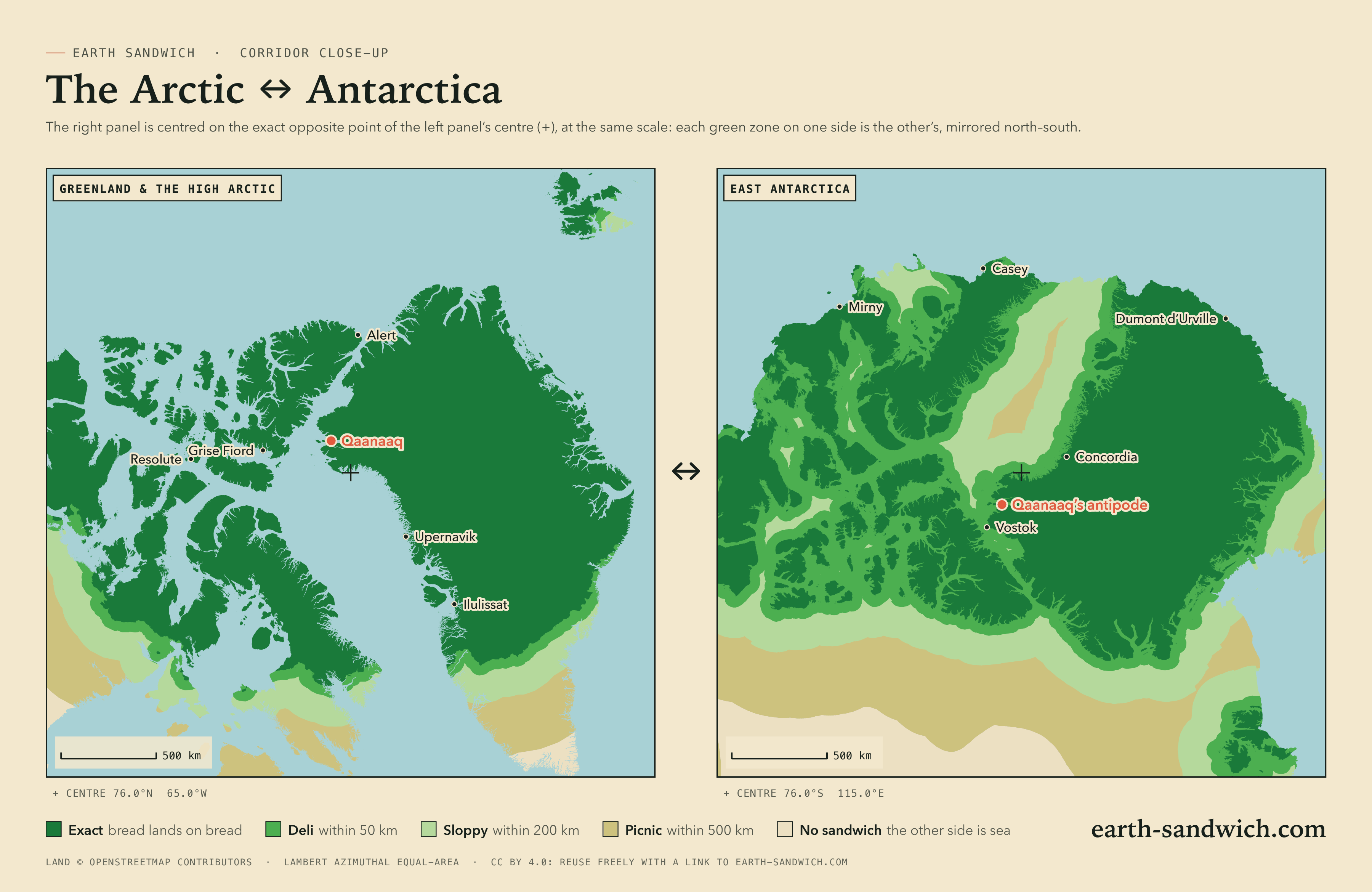
This corridor has more land opposite land than almost any other, and almost nobody in it. Greenland and the islands of the Canadian Arctic sit on the Antarctic ice sheet; the Antarctic Peninsula sits on Siberia. Sandwich Law calls anything poleward of 60° expedition class: legal and heroic, but left out of the feasibility rankings. This is the guide to making one anyway.
How it lines up Towns and stations Twins The highest Timing Getting there
How the two sides line up
Greenland’s ice cap lands on East Antarctica, the Greenland coast between Ilulissat and Upernavik facing the plateau around Concordia and the coast of Wilkes Land. The Canadian Arctic islands land on the stretch of coast between Mawson and Mirny: Kugluktuk faces Mawson Station, Naujaat Mirny Station, Pangnirtung the country near Casey. Northern Alaska reaches Dronning Maud Land, where Utqiaġvik’s antipode lies on the ice 415 km from Russia’s Novolazarevskaya station.
The Antarctic Peninsula lands on Siberia, in Yakutia. Esperanza Base is 57 km from the antipode of Kysyl-Syr, and the stations on King George Island, among them Frei and King Sejong, all face the Vilyuy valley. The South Orkneys’ Orcadas Base faces Ust-Maya, on the Aldan.
The misses are the famous places. The South Pole’s antipode is the North Pole, in the Arctic Ocean 704 km from land. McMurdo faces the Greenland Sea off the north-east coast of Greenland; Vostok faces the Kane Basin between Greenland and Ellesmere Island, 12 km from land. Nuuk misses by 232 km, and Longyearbyen, on Svalbard, faces the Ross Sea.
Every town and station, and where its other slice lands
Every Arctic town above 1,000 people in Greenland, Canada and Alaska, and the larger towns of the Russian and Norwegian Arctic, each listed if its other slice lands within 300 km of land. On the other side, every Antarctic research station that GeoNames gives a population, which leaves out abandoned bases and summer camps. Exact means land, or ice on land, opposite land at the place’s own point; where the other slice would get wet, the table gives the nearest spot from which an exact sandwich is possible.
| Place | Verdict | Where the other slice lands |
|---|---|---|
| Greenland | ||
| NuukSermersooq · 14,798 | SOGGY | Southern Ocean, 232 km from dry landNearest exact spot: 256 km away, 164 km from Maniitsoq (Qeqqata) |
| SisimiutQeqqata · 5,227 | EXACT | Dry land 598 km from Dumont d'Urville Station (French Southern Territories) |
| IlulissatAvannaata · 4,413 | EXACT | Dry land 542 km from Dumont d'Urville Station (French Southern Territories) |
| AasiaatQeqertalik · 3,005 | EXACT | Dry land 587 km from Dumont d'Urville Station (French Southern Territories) |
| ManiitsoqQeqqata · 2,534 | SLOPPY | Southern Ocean, 101 km from dry landNearest exact spot: 112 km away, 62 km from Sisimiut (Qeqqata) |
| TasiilaqSermersooq · 1,985 | SLOPPY | Southern Ocean, 131 km from dry landNearest exact spot: 143 km away, 143 km from Tasiilaq (Sermersooq) |
| UummannaqAvannaata · 1,407 | EXACT | Dry land 514 km from Concordia Station |
| UpernavikAvannaata · 1,129 | EXACT | Dry land 258 km from Concordia Station |
| QasigiannguitQeqertalik · 1,081 | EXACT | Dry land 528 km from Dumont d'Urville Station (French Southern Territories) |
| Canada | ||
| IqaluitNunavut · 7,429 | SOGGY | Southern Ocean, 237 km from dry landNearest exact spot: 244 km away, 124 km from Pangnirtung (Nunavut) |
| InuvikNorthwest Territories · 3,243 | EXACT | Dry land 78 km from Vechernyaya Base |
| Baker LakeNunavut · 2,061 | SOGGY | Southern Ocean, 237 km from dry landNearest exact spot: 248 km away, 241 km from Gjoa Haven (Nunavut) |
| IgloolikNunavut · 2,049 | EXACT | Dry land 362 km from Edgeworth David Base |
| Cambridge BayNunavut · 1,760 | DELI | Prydz Bay, 20 km from dry landNearest exact spot: 48 km away, 48 km from Cambridge Bay (Nunavut) |
| Pond InletNunavut · 1,555 | EXACT | Dry land 654 km from Vostok Station |
| PangnirtungNunavut · 1,504 | DELI | Southern Ocean, 1 km from dry landNearest exact spot: 1 km away, near Pangnirtung (Nunavut) |
| KinngaitNunavut · 1,396 | SLOPPY | Davis Sea, 104 km from dry landNearest exact spot: 105 km away, 105 km from Kinngait (Nunavut) |
| KugluktukNunavut · 1,382 | EXACT | Dry land 89 km from Mawson Station |
| Gjoa HavenNunavut · 1,349 | EXACT | Dry land 250 km from Davis Station |
| NaujaatNunavut · 1,225 | DELI | Davis Sea, 2 km from dry landNearest exact spot: 8 km away, near Naujaat (Nunavut) |
| Clyde RiverNunavut · 1,181 | EXACT | Dry land 467 km from Casey Station |
| Coral HarbourNunavut · 1,035 | SLOPPY | Davis Sea, 94 km from dry landNearest exact spot: 229 km away, 149 km from Naujaat (Nunavut) |
| Norman WellsNorthwest Territories · 1,027 | SLOPPY | Southern Ocean, 66 km from dry landNearest exact spot: 70 km away, 70 km from Norman Wells (Northwest Territories) |
| United States | ||
| UtqiagvikAlaska · 4,384 | EXACT | Dry land 415 km from Novolazarevskaya Station |
| Svalbard and Jan Mayen | ||
| LongyearbyenSvalbard · 2,368 | DELI | Ross Sea, 34 km from dry landNearest exact spot: 57 km away, 57 km from Longyearbyen (Svalbard) |
| OlonkinbyenJan Mayen · 14 | SLOPPY | Southern Ocean, 56 km from dry landNearest exact spot: 464 km away, 464 km from Olonkinbyen (Jan Mayen) |
| Iceland | ||
| ReykjavíkCapital Region · 118,918 | SOGGY | Southern Ocean, 302 km from dry landNearest exact spot: 560 km away, 337 km from Ísafjörður (Westfjords) |
| Russia | ||
| NorilskKrasnoyarsk Krai · 140,800 | SLOPPY | Southern Ocean, 66 km from dry landNearest exact spot: 78 km away, 78 km from Norilsk (Krasnoyarsk Krai) |
| TalnakhKrasnoyarsk Krai · 59,051 | SLOPPY | Southern Ocean, 73 km from dry landNearest exact spot: 86 km away, 78 km from Norilsk (Krasnoyarsk Krai) |
| Place | Verdict | Where the other slice lands |
|---|---|---|
| Orcadas Baseresearch station | EXACT | Dry land 53 km from Ust-Maya (Sakha, Russia) |
| McMurdo Stationresearch station | SLOPPY | Greenland Sea, 97 km from dry landNearest exact spot: 100 km away, 100 km from McMurdo Station |
| Showa Stationresearch station | EXACT | Dry land 280 km from Inuvik (Northwest Territories, Canada) |
| Mirny Stationresearch station | EXACT | Dry land 33 km from Naujaat (Nunavut, Canada) |
| Rothera Research Stationresearch station | EXACT | Dry land 107 km from Olenyok (Sakha, Russia) |
| Amundsen-Scott South Pole Stationresearch station | SOGGY | Arctic Ocean, 704 km from dry landNearest exact spot: 725 km away, 725 km from Amundsen-Scott South Pole Station |
| Villa Las Estrellasresearch station | EXACT | Dry land 143 km from Verkhnevilyuysk (Sakha, Russia) |
| Base Presidente Eduardo Frei Montalvaresearch station | EXACT | Dry land 144 km from Verkhnevilyuysk (Sakha, Russia) |
| SANAE IV Stationresearch station | SLOPPY | East Siberian Sea, 80 km from dry landNearest exact spot: 81 km away, 81 km from SANAE IV Station |
| Esperanza Baseresearch station | EXACT | Dry land 57 km from Kysyl-Syr (Sakha, Russia) |
| Casey Stationresearch station | EXACT | Dry land 170 km from Pangnirtung (Nunavut, Canada) |
| Davis Stationresearch station | DELI | The North Western Passages, 4 km from dry landNearest exact spot: 5 km away, near Davis Station |
| King Sejong Stationresearch station | EXACT | Dry land 144 km from Verkhnevilyuysk (Sakha, Russia) |
| Qinling Stationresearch station | DELI | Greenland Sea, 32 km from dry landNearest exact spot: 34 km away, 34 km from Qinling Station |
| Scottresearch station | SLOPPY | Greenland Sea, 99 km from dry landNearest exact spot: 102 km away, 100 km from McMurdo Station |
| Novolazarevskaya Stationresearch station | SOGGY | Chukchi Sea, 221 km from dry landNearest exact spot: 249 km away, 249 km from Novolazarevskaya Station |
| Jang Bogo Stationresearch station | SLOPPY | Greenland Sea, 63 km from dry landNearest exact spot: 64 km away, 34 km from Qinling Station |
| Zhongshan Stationresearch station | EXACT | Dry land 63 km from Cambridge Bay (Nunavut, Canada) |
| Neumayer Station IIIresearch station | SLOPPY | East Siberian Sea, 70 km from dry landNearest exact spot: 270 km away, 83 km from SANAE IV Station |
| Mawson Stationresearch station | EXACT | Dry land 89 km from Kugluktuk (Nunavut, Canada) |
| Base General Bernardo O'Higgins Riquelmeresearch station | EXACT | Dry land 53 km from Vilyuysk (Sakha, Russia) |
| Halley Research Stationresearch station | DELI | East Siberian Sea, 38 km from dry landNearest exact spot: 68 km away, 68 km from Halley Research Station |
| Progress Stationresearch station | EXACT | Dry land 64 km from Cambridge Bay (Nunavut, Canada) |
| Bharati Antarctic Stationresearch station | EXACT | Dry land 59 km from Cambridge Bay (Nunavut, Canada) |
| Palmer Stationresearch station | EXACT | Dry land 203 km from Nyurba (Sakha, Russia) |
| Troll Research Stationresearch station | SLOPPY | Arctic Ocean, 61 km from dry landNearest exact spot: 65 km away, 64 km from Troll research station |
| Maitri Stationresearch station | SOGGY | Chukchi Sea, 224 km from dry landNearest exact spot: 252 km away, 249 km from Novolazarevskaya Station |
| O Higginsresearch station | EXACT | Dry land 53 km from Vilyuysk (Sakha, Russia) |
| Vostok Stationresearch station | DELI | Kane Basin, 12 km from dry landNearest exact spot: 16 km away, near Vostok Station |
| Machu Picchu Baseresearch station | EXACT | Dry land 163 km from Verkhnevilyuysk (Sakha, Russia) |
| Kunlun Stationresearch station | SLOPPY | Arctic Ocean, 64 km from dry landNearest exact spot: 64 km away, 64 km from Kunlun Station |
| González Videla Antarctic Baseresearch station | EXACT | Dry land 181 km from Nyurba (Sakha, Russia) |
| Molodyozhnaya Stationresearch station | EXACT | Dry land 79 km from Inuvik (Northwest Territories, Canada) |
| Aboa Stationresearch station | SOGGY | East Siberian Sea, 293 km from dry landNearest exact spot: 467 km away, 81 km from SANAE IV Station |
| Concordia Stationresearch station | EXACT | Dry land 258 km from Upernavik (Avannaata) |
| Edgeworth David Baseresearch station | SLOPPY | Foxe Basin, 119 km from dry landNearest exact spot: 126 km away, 126 km from Edgeworth David Base |
| Vechernyaya Baseresearch station | EXACT | Dry land 78 km from Inuvik (Northwest Territories, Canada) |
| Sky Bluresearch station | EXACT | Dry land 368 km from Saskylakh (Sakha, Russia) |
| Kohnen Stationresearch station | SOGGY | Arctic Ocean, 378 km from dry landNearest exact spot: 383 km away, 95 km from Troll research station |
| Mizuho Stationresearch station | SLOPPY | Beaufort Sea, 112 km from dry landNearest exact spot: 118 km away, 118 km from Mizuho Station |
Twins
No Arctic town is within a kilometre of a station’s antipode; the closest pairs are about thirty kilometres apart.
The highest sandwiches
A sandwich’s elevation bonus is the height of one end plus the height of the other (Sandwich Law § 1.4). The Board scores it the way the map shows it: from the average height of the ground over cells about 20 km across, so every spot in a cell scores the same and you only need to be in the right cell, not on the summit. These are the corridor’s best cells, one per area, each with dry land at both ends.
- +5,760 m437 km from Upernavik (Avannaata)cell average 2,840 m328 km from Concordia Stationcell average 2,920 m
- +5,600 m570 km from Uummannaq (Avannaata)cell average 3,240 m659 km from Dumont d'Urville Station (French Southern Territories)cell average 2,360 m
- +5,520 m873 km from Pond Inlet (Nunavut, Canada)cell average 1,720 m220 km from Kunlun Stationcell average 3,800 m
- +5,360 m323 km from Pond Inlet (Nunavut, Canada)cell average 1,720 m425 km from Vostok Stationcell average 3,640 m
- +5,280 m592 km from Upernavik (Avannaata)cell average 2,200 m336 km from Concordia Stationcell average 3,080 m
Both ends are ice caps: the best cell averages 2,840 m on the Greenland ice sheet and 2,920 m on the East Antarctic plateau, more than 300 km from the nearest station at either end. It is the highest pair outside the Andes corridors, behind only Vietnam and Peru and China and Argentina.
Timing it
The window. Both slices must go down within five minutes of the same UTC instant (Sandwich Law § 2.1). The sandwich lobby holds you to it: when the first slice lands, the other side has five minutes.
The clocks. Agree the minute in UTC: stations keep time zones of their own choosing, often not the one their longitude suggests.
The light. Here the light makes its own rules. Two exactly opposite points are never in daylight together, and around the June and December solstices the sun never sets at one end and never rises at the other, so there is no moment when both are lit. Near the equinoxes it is the other way round: the sun skims the horizon at both ends for twenty minutes or more, twice a day.
The seasons. The Antarctic season, roughly November to February, is when stations are reachable and fully staffed; that is the Arctic winter, when the Greenland end is dark.
Getting there
Nobody gets to either end by chance. The realistic Earth sandwich here is between two people already on the ice: a station member in Antarctica and someone in Greenland, Nunavut or northern Alaska. Sandwich Law counts ice sheets as expedition-class ground, and a sandwich poleward of 60° is legal and recorded, but ranked apart.
Then open an attempt in the sandwich lobby. It gives you a code and a link to send through whatever channel you already share, shows both slices when they arrive, and runs the five-minute window. Expedition rules apply before sandwich rules: go only where your station or guide says it is safe. The exact grade allows a kilometre of slack, which is usually enough to find somewhere you are allowed to stand.
City antipodes on this corridor
No city above a million people is on this corridor.
How this was worked out: towns, populations and their centre points from GeoNames (a place within 20 km of one three times its size is left out as its suburb); Antarctic stations from GeoNames’ own list for Antarctica; land or sea from the OpenStreetMap coastline the map uses; verdicts at each place’s own point, nearest exact spots and elevation bonuses from the same coastline and the verifier’s 0.2° grid (Natural Earth land, ETOPO 2022 relief); sea names and borders from Natural Earth; the share of people with land opposite from GHS-POP 2020 (European Commission, Joint Research Centre, CC BY 4.0), at about 1 km resolution. Clock and daylight figures are for exactly opposite points on a sphere with standard refraction. Generated 2026-09-29.